Get stuck in tomorrow morning

South Australian Surf Forecast by Craig Brokensha (issued Monday November 8th)
Best Days: Late today on the Mid Coast, tomorrow morning both coasts, Wednesday for the keen Mid Coast
Features of the Forecast (tl;dr)
- Moderate sized, mid-period SW swell tomorrow with variable offshore winds early, swinging onshore late morning then strengthening from the S/SW into the PM
- Easing surf with gusty S/SE winds Wed
- Small Thu with strong E/SE tending SE winds
- Small Fri with fresh S winds
- Small to tiny Sat with S/SW-SW winds
- Building S/SW swell Sun PM with early W tending strong SW winds
- Moderate sized S/SW swell Mon with gusty S/SW winds
Recap
Friday's fun pulse of W/SW swell across the Mid Coast eased back quite a bit into Saturday leaving tiny 0.5-1ft waves with an onshore change, clean early down South but only small and to 2ft ahead of the change.
Sunday was poor with onshore, small surf down South and tiny, clean 1ft waves on the Mid which pulsed a little through the day to 1-2ft with a new swell though with bumpy conditions. The surf cleaned up late but it was also full.
Today the swell was back to a tiny 1ft on the Mid with less than ideal conditions, small and bumpy down South. Throughout the past few days the swell on the Mid has been very tidally effected and we're seeing 1-2ft sets again showing as it pushes back in.

Good kick in size yesterday afternoon
This week and weekend (Nov 9 - 14)
 Tomorrow is well worth capitalising on as we'll see a good pulse of new, mid-period SW swell with favourable winds ahead of a run of poor surf and conditions.
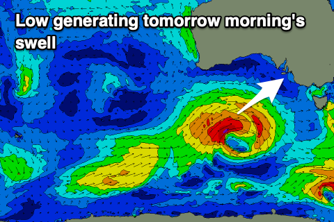
The swell generating fetch linked to this swell was a good low that formed south-west of Western Australia on the weekend, generating a fetch of W/SW gales through our south-western swell window.
Positioning wise, while not ideally in the Mid Coast's swell window it should still produce some fun size with sets to 2ft due on the favourable parts of the tide, while Middleton should come in at a good 3-4ft, if not for the odd bigger one towards Goolwa.
Winds will be great in the morning with light local offshore breezes (NW down South and E/SE on the Mid), shifting light onshore late morning before strengthening into the afternoon as a trough moves through. Therefore get in before lunch for the best conditions.
A strong high will slowly edge in from the west on Wednesday bringing strong S/SE winds as the swell eases, drooping from 1-1.5ft on the Mid Coast and 3ft down South.
Winds are due to swing more E/SE on Thursday but remain strong, creating poor conditions down South with a junky mix of weak swells, clean but tiny on the Mid, with wind reverting back to the S'th on Friday as another trough pushes up from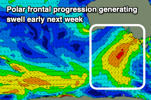 the south.
There's no improvement unfortunately for the weekend as we see a strengthening though relatively weak polar frontal progression projecting up and into Victoria. This will see onshore SW-S/SW winds persisting across the South Coast Saturday with no quality swell, tipping W'ly early Sunday but then back strong to the SW late morning. Swell wise, mid-period energy is due to build Sunday with the SW change (small and weak early with the W'ly wind), peaking Monday in the 4-5ft+ range but with S/SW winds.
Continued frontal activity projecting towards Victoria, around the south-east flank of a blocking high to our south-west will keep conditions poor early-mid next week as the swell starts to ease, possibly improving late in the week but with no decent swell.
Therefore get stuck in tomorrow and make the most of the window of clean conditions.