Windy weekend with a mix of swells, larger next week with varying conditions

South Australian Surf Forecast by Craig Brokensha (issued Friday September 17th)
Best Days: Protected spots for the keen down South tomorrow, Sunday morning down South, both coasts Wednesday morning, South Coast Thursday and Friday
Features of the Forecast (tl;dr)
- Inconsistent SW groundswell tomorrow with strong W/NW winds
- Building W/SW swell tomorrow on the Mid with strong W/SW-W winds
- Moderate sized, mid-period SW swell Sun with strong N/NW tending W/NW winds
- Large SW groundswell building Mon with strong W/SW tending SW winds
- Large, easing SW swell Tue with strong SW winds
- Easing surf Wed with morning variable winds on both coasts and weak sea breezes
- Strong new S/SW-SW groundswell building Thu with mod-fresh N/NW winds, easing Fri with dawn NW tending strong SW winds
Recap
Tiny, glassy 1ft waves hanging in on the Mid Coast yesterday, flat today with a local N'ly windswell. The South Coast was a clean, fun 1-2ft across Middleton and Goolwa yesterday, better on the magnets, while today we're back to the tiny stuff.
This weekend and next week (Sep 18 - 24)
It's been a tricky week for the leading global forecast models, with both of them struggling to resolve a mid-latitude low that's currently forming and pushing in from the west.
Initially it was expected to be sitting high in the Bight, generating swell mainly for the Mid Coast, then on Wednesday the models had it shifted a little further south. Today, we've got agreement with the models and the low is due to be a little weaker in strength, resulting in a slight downgrade in the weekend outlook across both coasts.
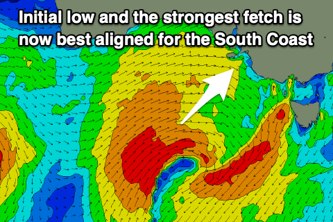 Last night, a fetch of strong W/SW winds under Western Australia were generated and we're seeing similar strength winds maintained today as the low dips east-southeast. Stronger gales are due to be generated in the South Coast's swell window today and this should produce some decent size for Sunday, coming more from the SW direction.
But coming back to tomorrow and firstly, an inconsistent SW groundswell should fill in, generated last Sunday and Monday by a strong polar frontal progression in the Heard Island region. Inconsistent 3ft sets are due across Middleton (increasing a little further later), while the Mid Coast looks to see 2ft waves as a mix of mid-period swell and windswell fill in as the low moves across us this evening.
The afternoon should see surf more to 2-3ft on the Mid and winds will be strong from the W-W/SW most of the day down South, W/NW tending W/SW on the Mid.
Come Sunday The Mid looks to drop back a touch to around 2ft to possibly 3ft, with more size down South as the mid-period SW energy fills in, providing surf in the 4ft range across Middleton. Winds will great for the South Coast and fresh to strong from the N/NW, shifting stronger W/NW into the afternoon, so hit the more exposed spots early.
This shift in winds will be associated with the secondary, stronger low moving in from the south-west, bringing with it our large pulse of SW groundswell for the afternoon.
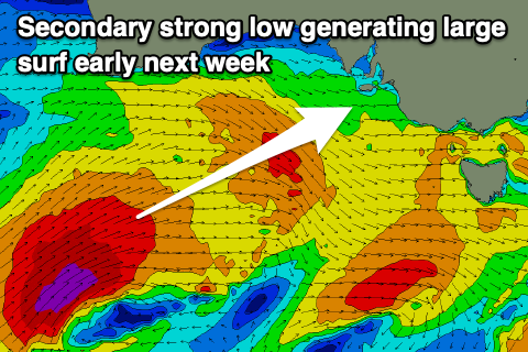 The low is forecast to develop south-southwest of Western Australia this evening, projecting a fetch of gale to severe-gale W/SW winds up towards us through tomorrow, weakening slightly Sunday.
The swell will build through Monday and peak into the afternoon with Middleton building to the 6ft range, while the Mid should kick back to 3ft with some localised windswell in the mix.
Winds will unfortunately be poor and strong from the W/SW tending SW in the wake of the low passing under us Sunday evening, remaining strong from the SW on Tuesday as the swell eases.
We'll hopefully see winds ease into Wednesday and swing back to the W/NW across the South Coast, variable early on the Mid but with less energy in the water. The Mid looks to ease back to 1-2ft while Middleton will still be solid and to 3-4ft or so.
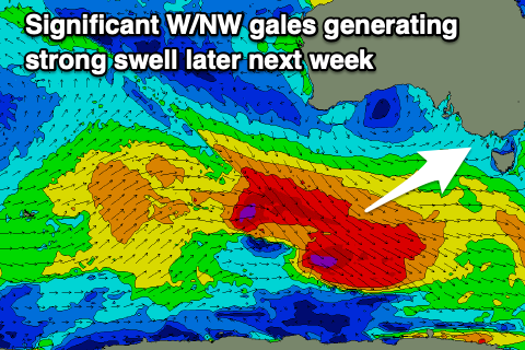 Now, as touched on in Wednesday's update, a strong new SW-S/SW groundswell is due into the end of the week, generated by a significant polar low and fetch of gale to severe-gale NW tending W/NW winds setting up under the country early next week.
This looks to generate a moderate-large S/SW-SW groundswell event for later next week with a couple of embedded pulses. Size wise we're looking at surf to 4-5ft or so across Middleton Thursday/Friday with N/NW winds on the former and a mid-morning SW change on the later, but we'll review this on Monday. Have a great weekend!
Comments
I am not sure what is going on lately, swell forecast has been pretty inaccurate. For example today swell forecast shows 3 feet around Middleton but its only about 1 foot. It seems most people just look at the CAMs and make up their own mind.
Hmm, today's swell wasn't from the best source, very long-range and inconsistent. There's much better surf due tomorrow.