Fun, smaller waves for the South Coast ahead of large swells next week

South Australian Surf Forecast by Craig Brokensha (issued Wednesday August 18th)
Best Days: South Coast tomorrow, Friday, Saturday, Sunday morning, both regions Tuesday
Features of the Forecast (tl;dr)
- Inconsistent W/SW groundswell for tomorrow with variable NE tending fresher N/NW winds after lunch
- Easing W/SW groundswell Fri with fresh N/NW-NW winds
- Inconsistent W/SW swell for Sat, a bit better and building further on the Mid Sun
- Moderate NW winds Sat, strong N/NW tending W/NW winds Sun
- Large mid-period W/SW swell for Mon AM with a larger W/SW groundswell arriving late arvo, easing slowly Tue
- Strong W/SW tending SW winds Mon, variable Tue ahead of weak sea breezes
Recap
The swell was still solid yesterday morning down South and to 4-5ft across Middleton with cleaner conditions under a W/NW breeze, cleaner on the Mid but a full 1-2ft in the morning. The afternoon offered more consistent sets with some slight bump.
Today the Mid was cleaner and offering fun 1-2ft sets, great down South and to 3ft across Middleton. Expect the swell to ease further as winds go variable.
This week and weekend (Aug 19 - 22)
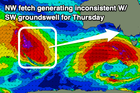 The swell seen since the start of the week will continue to ease in size through tomorrow, but this will be overridden by an inconsistent, tricky, new W/SW groundswell. This swell was generated by an unfavourably aligned fetch of gale to severe-gale NW winds tracking south-east from the Indian Ocean on Sunday and Monday.
The fetch was primarily aimed towards the Antarctic Shelf but we should see some small swell spreading out radially from the source, filling in tomorrow and providing 2ft surf off Middleton with 3ft sets at Goolwa and 1ft waves on the Mid Coast.
Winds look favourable for the South Coast and variable NE in the morning, shifting N/NW and increasing from early afternoon. With this the afternoon surf might be the pick.
 Come Friday the swell will be on the way out and smaller but with fresh N/NW-NW winds on the South Coast.
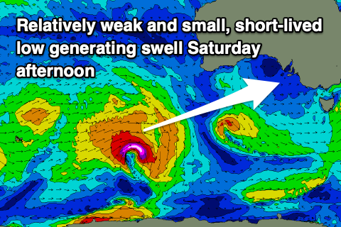
Moving into the weekend and a new, inconsistent W/SW groundswell is due to fill in Saturday, likely peaking through the late morning/early afternoon.
This swell has been generated by a short-lived but strong low firing up south-west of Western Australia yesterday, with it weakening today. It'll be inconsistent but sets should come in around 2-3ft across the Middleton stretch, with the Mid Coast seeing 1-1.5ft waves on the favourable parts of the tide.
Moderate NW winds are due all day Saturday, creating poor conditions on the Mid Coast and clean conditions in protected spots down South. A better, more consistent and slightly bigger W/SW swell is due to fill in Sunday, generated by a secondary frontal progression generating weakening strong to gale-force W/SW winds while projecting up towards and then under Western Australia.
There'll be mid-period energy ahead of some better groundswell into Monday morning but size wise the Mid Coast should build through Sunday and reach 2ft on the sets, with the South Coast holding that 2-3ft range across Middleton.
A stronger, approaching frontal system will unfortunately bring strengthening N/NW tending W/NW winds, creating choppy conditions on the Mid and favouring the South Coast. It might also bring some additional windswell on top of the swell for the Mid late in the day.
This frontal system will actually be the remnants of a much stronger polar low pushing up and towards us, forming south-west of Western Australia on Thursday evening. We'll see this low project gale to severe-gale W/SW winds up through our western swell window, weakening while pushing through the Bight and across us Sunday evening and Monday.
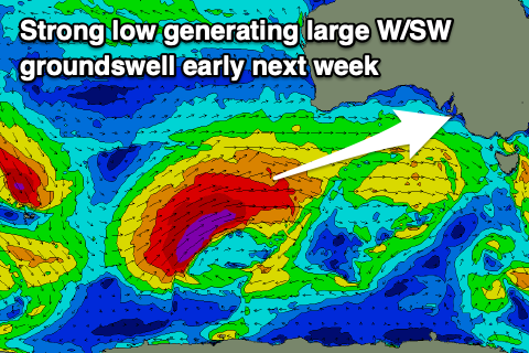 A large W/SW groundswell is due from this low later Monday and Tuesday morning but ahead of this, mid-period swell from the weaker front is due Monday morning, coming in at 3ft on the Mid Coast and building from 3-4ft down South across Middleton.
The arrival of the groundswell looks to be late afternoon, kicking the swell further to 3ft+ on dark across the Mid and 4-5ft+ down South. The peak might occur overnight but Tuesday morning should still see good 3ft surf on the Mid and 4-5ft+ waves down South.
Looking at the local winds and strong, easing W/SW tending SW winds are due Monday, with Tuesday looking much better for all locations with variable winds due on the Mid Coast and light W/NW around Victor down South. Afternoon sea breezes look weak so we should see favourable conditions most of the day.
Longer term we may see a moderate-large, reinforcing S/SW groundswell for late week, but we'll have a closer look at this on Friday.