Improving surf late week and into the weekend

South Australian Surf Forecast by Craig Brokensha (issued Monday August 9th)
Best Days: Mid Coast for the keen Thursday, protected spots Thursday and Friday down South, Saturday and Sunday both coasts, Monday onwards South Coast
Features of the Forecast (tl;dr)
- Fading surf tomorrow with strengthening N/NW winds
- Mix of mid-period and strong W/SW groundswell building late Wed with fresh W/NW tending stronger W winds
- Mod-large peak in W/SW swells Thu with moderate NW tending W/NW winds, easing Fri with fresher NW tending W/NW winds
- Mod-large SW tending S/SW swell filling in Sat with light offshore tending variable winds, similar Sun with an easing S/SW swell
Recap
A great pulse of moderate-large SW groundswell on Saturday with clean conditions and lots of options for experienced surfers across the South Coast, excellent on the more exposed beaches Sunday with a drop in swell and straight offshore wind.
The Mid Coast was tiny though surfable for the desperate and beginners all weekend.
Today the swell has eased back a bit quicker than expected leaving 2ft+ waves across Middleton, best on the swell magnets and tiny on the Mid.
This week and weekend (Aug 10 - 15)
Tomorrow and Wednesday morning aren't expected to offer much at all in the way of surf as the weekend's swell continues to ease in size and power, tiny across Middleton and with strengthening N/NW winds tomorrow, kicking up a tiny windswell on the Mid.
Fresh W/NW tending stronger W winds are then due Wednesday as a weakening mid-latitude frontal system pushes in from the west, with a moderate-large, long-period W/SW groundswell to follow in its wake.
This swell started to be generated on the weekend by a significant polar frontal progression firing up towards Western Australia from the Heard Island region, generating fetches of severe-gale to storm-force W/SW winds through our medium-range western swell window.
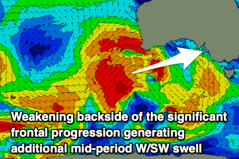 The progression is slowly weakening while pushing up and across Western Australia today, with great fetches of gale to severe-gale W/SW winds continuing to be aimed towards us, pushing under Western Australia and into the Bight during tomorrow while weakening further.
This will add some additional mid-period swell to the mix, which is likely to be seen Wednesday afternoon ahead of the groundswell Thursday.
We're likely to see the Mid Coast building to 2-3ft by close of play Wednesday but with that strengthening W breeze, with Thursday coming in at a solid 3ft. The South Coast should build to 3-4ft late in the day Wednesday across Middleton, with Thursday seeing strong 4-5ft sets between Middleton and Goolwa.
Winds should abate into Thursday and shift back to the NW through the morning across the South West, holding from the W/NW into the afternoon. The Mid Coast will be bumpy but surfable all day.
Similar though fresher NW tending W/NW winds are due Friday as the mix of W/SW swells start to ease.
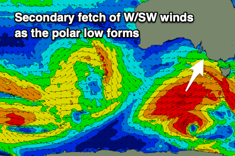 Moving into the weekend, and we've got another good dose of SW tending S/SW groundswell due Saturday, generated by a great pre-frontal fetch of W/NW gales moving in behind the weakening mid-latitude frontal system, south-west of Western Australia. The front will spawn into a low with better aligned gale to near severe-gale W/SW winds projected through our southern swell window.
The swell looks to start SW Saturday morning, shifting S/SW through the day and building from 3-5ft to 4-6ft across Middleton through the day, with the Mid holding around 2ft all day. Conditions are shaping up nicely across both regions at this stage with variable tending local offshore winds due in the morning, then variable into the afternoon, similar Sunday as the swell eases, opening up plenty of options for a surf.
Longer term winds look to remain good for the South Coast with a fun, reinforcing S/SW groundswell mid-week, but more on this Wednesday.