OK day of waves tomorrow, stormy late week

South Australian Surf Forecast by Craig Brokensha (issued Monday July 12th)
Best Days: Keen surfers Mid Coast tomorrow AM, and the South Coast for the patient, Mid Coast Saturday afternoon and Sunday, South Coast next Monday
Features of the Forecast (tl;dr)
- Inconsistent W/SW groundswell and easing mid-period W swell tomorrow with moderate N/NE winds, strengthening into the afternoon
- Tiny fading surf Wed with stronger N/NW winds
- New W swell for the Mid Friday with strengthening W/NW winds, stormy late
- Large, stormy W/SW swell Sat AM with strong, but easing W/SW winds
Recap
Tiny clean surf all weekend down South with nothing to really surf at all. The Mid Coast's W'ly swell for Saturday morning didn't really eventuate with infrequent 1-1.5ft+ waves for the desperate and patient. Yesterday was bumpy and flat on the Mid, but a new W/SW swell is on the build today though with average, N'ly winds. The South Coast is still marginal as well with the W'ly direction failing to get around Kangaroo Island.
This week and weekend (Jul 13 - 18)
Firstly looking at today, and a mid-latitude low that's pushing in and across the state is bringing an increase in W'ly swell that should reach 2ft+ on the Mid this afternoon but with onshore W/NW winds.
The swell is due to ease back from 2ft tomorrow morning, though winds will be best for the South Coast and moderate from the N/NE, stronger from the N into the afternoon.
There'll be no real size on the South Coast though owing to the low and fetch riding high in the Bight, but an inconsistent W/SW groundswell should provide 1-2ft sets across Middleton, holding tomorrow morning and then fading Wednesday from 1-1.5ft.
 Winds will shift stronger N/NW on Wednesday (similar Thursday) ahead of another, slow moving mid-latitude low pushing in from Western Australia, but again it looks to be riding too high in the Bight to generate any swell for the South Coast.
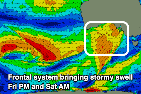
Even the Mid Coast will struggle with winds angled W/NW and just within its swell window, producing an acute W'ly swell for Friday to 2ft or so. Winds on Friday will unfortunately be strong from the W/NW associated with the mid-latitude pushing in from the west, even stronger on Saturday as a significant cold front pushes in.
Now, this strengthening cold front will bring a stormy increase in solid swell for the Mid Coast while also kicking up plenty of size for the South Coast, though at this early stage the models diverge slightly on its timing and strength.
 In either case we're likely to see stormy 2-3ft waves developing on the Mid Friday afternoon, coming in at 4ft on Saturday with strong but easing W/SW winds.
The South Coast looks to come in around 4-5ft across Middleton on Saturday but with those strong W/SW winds, easing Sunday as winds linger from the W/SW-SW. The Mid may see more variable winds in the morning as the swell eases 2-3ft Sunday morning.
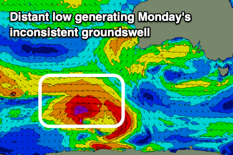
Following this strong frontal progression there's no major trailing activity, but an inconsistent, reinfrocing SW groundswell is due Monday from a polar low firing up east of Heard Island on Wednesday. This should keep 3-4ft sets hitting Middleton with more favourable W/NW-NW offshores, though we'll confirm this Wednesday.
Comments
Last week end was fun surfing taking out an 8ft softie at 2ft waits point,