Fun options on the weekend, better early next week

South Australian Surf Forecast by Craig Brokensha (issued Friday June 25th)
Best Days: Beginners on the Mid tomorrow morning and Sunday, South Coast tomorrow and Sunday morning, South Coast Monday and Tuesday
Features of the Forecast (tl;dr)
- Easing S/SW groundswell and mid-period S swell tomorrow with moderate W/NW winds, strengthening into the PM (variable early on the Mid)
- Small, reinforcing S/SW groundswell Sun with W/NW-NW winds, shifting light SW into the PM (variable on the Mid)
- Good S/SW swell Mon with moderate N/NE tending lighter N/NW winds, easing Tue with fresh N/NE tending lighter N winds
- Mix of W/SW swells filling in Thu with strong W/SW tending W/NW winds, larger Fri with strong W/SW tending SW winds
Recap
Tiny clean surf down South yesterday, becoming choppy but remaining tiny into the afternoon, while the Mid Coast saw a stormy building swell into the afternoon, reaching 3ft+ across most spots.
Today, with the easing of wind and clearing of low to our east we've seen the swell drop back to a junky 2ft with a moderate to fresh onshore wind, while the South Coast is seeing a mix of new S/SW groundswell and mid-period S'ly swell with sets to 3-4ft across Middleton and a morning W/NW breeze.
Winds will shift S'ly around midday, so get in soon.
This weekend and next week (Jun 26 – Jul 2)
Today's mix of SW groundswell and mid-period S'ly swell (from the base of the low that moved in yesterday) will ease back in size through tomorrow with sets due to ease back from the 3ft range across Middleton, tiny and to 1-1.5ft on the Mid Coast.
Winds will quickly revert back to the W/NW tomorrow morning down South and be variable early on the Mid Coast, creating clean conditions ahead of strengthening W/NW winds into the afternoon.
 It looks like we'll hit a temporary low point in swell Sunday morning with Middleton coming in around 2-3ft, while a fun new mid-period S/SW swell will push in on Monday. Conditions will be favourable again Sunday morning with variable winds on the Mid, though tiny 1-1.5ft waves with a light to moderate W/NW-NW breeze down South, shifting light SW into the afternoon.
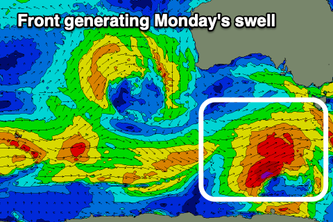
Monday's swell will be generated by a polar front that's currently south of WA, on the polar shelf, generating strong to gale-force W/NW-W winds. We'll see the front form into a low south-west of Tasmania tomorrow, generating stronger W/SW gales more in our southern swell window before passing east under that state Sunday.
The swell will be mostly mid-period energy but consistent and from a good direction, peaking Monday morning to 3-4ft across Middleton and 1ft across the Mid Coast. Conditions will be great with a moderate N/NE tending variable N/NW breeze, great again Tuesday as the swell eases back from the 2-3ft range with fresh N/NE tending lighter N winds.
Another low point in swell is due Wednesday with stronger N-N/NW winds ahead of a weakening mid-latitude frontal system.
The earlier stages of this frontal system will see a great fetch of gale-force W/SW winds projected through our medium range western swell window, weaken while pushing across and under Western Australia.
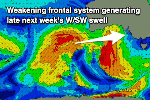 A secondary front generating a slim fetch of severe-gale W/NW winds under WA should generate some additional swell but size wise we're looking at a moderate sized W/SW swell filling in Thursday ahead of a secondary pulse Friday.
Size wise the Mid Coast should see building surf to 2-3ft, with increasing sets to 3-4ft possibly late Thursday down South, holding Friday.
The Mid looks to become bigger Friday and to 3-4ft as another strong front pushes up and into us, but this will bring strong W/SW tending W/NW winds on Thursday, and then strong W/SW tending SW Friday.
Following this a high looks to move in with winds slowly shifting S and then around to the NE early the following week along with easing surf. More on this Monday though and in the meantime, have a great weekend!