Windy end to the week, better from the weekend

South Australian Surf Forecast by Craig Brokensha (issued Wednesday June 23rd)
Best Days: Keen surfers Friday, beaches Saturday morning, keen surfers Tuesday and Fri
Features of the Forecast (tl;dr)
- Small pulse of W swell for the Mid tomorrow PM mixed in with windswell along with strong N tending W winds, easing Fri with fresh W/SW-SW winds, shifting S'ly late afternoon
- Inconsistent S/SW groundswell Fri with early W/NW winds down South, easing Sat with fresh W/NW winds
- Small, reinforcing S/SW groundswell Sun with W/NW winds, possibly tending NW late
- Good S/SW swell Mon with N/NE tending NE winds, easing Tue with fresh N/NE winds
Recap
Clean though tiny surf across Middleton, better at Waits and Parsons, tiny on the Mid Coast and wind affected.
Today the surf has bottomed out down South and the Mid is seeing a choppy, 1-2ft of N/NW windswell.
This week and next (Jun 24 – Jul 2)
The surf will remain tiny tomorrow and winds will become stronger from the N'th ahead of a W'ly change into the afternoon which will also kick up some local windswell along with a small W'ly pulse.
Sets to a choppy 2ft are due on the Mid Coast but with that strong onshore wind, while Friday should still see a period of dawn W/NW winds, shifting SW through the morning and stronger S into the afternoon.
This will be with a new, inconsistent SW groundswell, generated by a polar low earlier this week.
Middleton should see inconsistent 3ft sets while the Mid Coast will be a choppy 2ft, easing through the day as winds shift S'ly late, creating improving conditions. The trough linked to Friday's shift in winds will also generate some mid-period S'ly swell for the afternoon down South, possibly pushing to 3-4ft as a fetch of strong S'ly winds are aimed through our swell window.
Friday's mix of swells are due to ease into Saturday, dropping from 3ft across Middleton and winds will improve, shifting W/NW and holding all day as another cold front approaches from the west. The Mid looks to ease back to 1-1.5ft.
A reinforcing pulse of S/SW swell for Sunday is on the cards but this only looks to keep 2-3ft waves hitting Middleton, 1-1.5ft on the Mid Coast and a fresh NW breeze will continue to favour protected spots down South, easing late in the day.
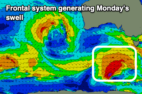 A better swell is due Monday, generated by a polar front projecting a fetch of W/SW gales through our south-western and then southern swell window from Friday through Saturday.
The swell will be mid-period in nature but offer some fun size with 3-4ft waves across Middleton through the morning, easing into the afternoon, while the Mid Coast will drop back to 1ft or so.
Winds look excellent for Monday as a strong mid-latitude frontal progression pushes up towards Western Australia, tipping winds back to the N/NE, holding from the NE into the afternoon down South and being NE tending light NW on the Mid Coast.
Conditions look to remain clean as the swell eases Tuesday but it'll be small and back to 2ft or so.
Longer term, the mid-latitude frontal activity pushing up towards WA won't be too favourable for swell production across our region, but the remnants of this activity looks to push through the Bight mid next week, generating some new mid-period W/SW swell late week.
Other than that the Souther Ocean storm track looks to remain relatively quiet as penned in this article yesterday. Keep checking back for any change to the situation in coming updates though.