Fun, windy South Coast, then interesting Mid Coast

South Australian Surf Forecast by Craig Brokensha (issued Friday June 4th)
Best Days: South Coast Sunday through Monday, protected spots South Coast Tuesday morning, Mid Coast on dark Tuesday and Wednesday
Features of the Forecast (tl;dr)
- Easing mid-period S/SW swell tomorrow with fresh N/NW tending NW winds
- Building mid-period SW swell Sun with fresh N/NW winds, holding Mon AM with stronger N/NW winds, tending NW late
- Slightly bigger mid-period S/SW swell late Mon, easing Tue with fresh W/NW tending strong W/SW winds
- Mod-large W/SW swell building Tue with winds tending S on dark on the Mid, easing Wed with strong S winds
Recap
Light winds at dawn yesterday and workable 2ft waves across Middleton for the keen, choppier into the afternoon with a fresher onshore breeze. The Mid Coast saw tiny, clean 1-1.5ft waves in the morning, bumpy through the afternoon, similar today but with lots of lump and bump.
The South Coast has increased in size but conditions are still bumpy and for the keen around Middleton.
This weekend and next week (Jun 5 - 11)
Today's mix of new swells across the state will peak this evening, with a drop in mid-period S/SW energy due tomorrow down South as winds swing back offshore.
Middleton should see good 3ft+ sets (under model forecasts), with tiny 1ft waves on the Mid Coast under a fresh N/NW tending NW breeze.
A temporary low point in swell is due Sunday morning down South, ahead of some new, mid-period SW swell through the day, generated by strong to gale-force pre-frontal W/NW winds moving in south of Western Australia today.
Middleton should build back to 3ft through the day (smaller early) with 1-1.5ft sets on the Mid Coast.
Similar sized waves are due Monday morning, but we'll see a slightly better, additional mid-period S/SW swell for the afternoon. The source of this swell will be a broader trailing fetch of strong to gale-force W/SW winds on the backside of the pre-frontal winds, with Middleton due to kick to 3-4ft late and ease from a similar size Tuesday morning.
Winds will be great on Sunday and fresh out of the N/NW, stronger N/NW tending late NW on Monday as a deep, cold, mid-latitude low pushes in from the west.
A building NW windswell should be seen on the Mid Coast to 2ft+ through the afternoon Monday, larger out of the W/SW on Tuesday as a strong W/SW change moves through (discussed in more detail below). The South Coast is likely to see a dawn W/NW breeze around Victor, then tending SW and then S into the afternoon.
Coming back to the Mid Coast and a moderate-large W/SW swell is due to build Tuesday, peaking Wednesday as a strong polar low projects a fetch of strong to near gale-force W/SW tending SW winds up towards Western Australia, through the Bight Sunday and Monday.
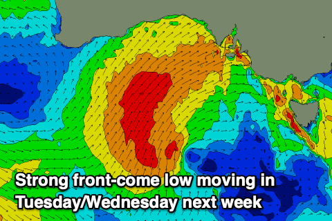 The front will push through Tuesday but be very slow moving as a mid-latitude low forms, swinging winds from the W/SW to S'th. The timing of this is still a little hazy but it should be late.
Size wise, the Mid Coast should build to 3ft+ through Tuesday afternoon, with onshore winds tending S on dark, easing back from 3ft on the sets Wednesday morning along with strong S-S/SW winds
The South Coast will increase in size as well but will become a mess with the strong S winds, persisting Thursday out of the S/SE with moderate levels of S/SE windswell.
Winds don't look to improve until next weekend, but by then there'll be no swell left in the tank due to the blocking effects of the mid-latitude low. Next week doesn't hold too much potential either, but more on this Monday. Have a great weekend!
Comments
Forecast showing easterly winds in winter, wtf!!!
Hi guys, what a great Saturday morning surf at Middleton was; great to see some great swell on the south coast; owe Danny Boy;;