Fun windows down South before going onshore next week

South Australian Surf Forecast by Craig Brokensha (issued Wednesday June 2nd)
Best Days: This afternoon, early tomorrow down South, Saturday, Sunday and Monday South Coast
Features of the Forecast (tl;dr)
- Easing mid-period SW swell Thu with local offshore tending S/SW winds mid-late morning
- Mix of new swells Fri with strong S'ly winds, easing Sat with mod-fresh N/NW tending stronger NW winds
- Building W/SW swell Sun with fresh NW tending N/NW winds, holding Mon with fresh-strong N/NW tending W/NW winds ahead of a late change
- Stormy S'ly windswell mid-late next week
Recap
Tiny peelers across Middleton yesterday and today, a bit better across more exposed spots for the keen. The Mid Coast was tiny yesterday with a little bump in swell today though only to 1ft or so.
Our new, inconsistent mid-period SW swell is now providing 2ft sets across Day St and Cliffs and we might see the odd 3ft'er if we're lucky into the late afternoon as winds go variable.
This week and weekend (Jun 3 - 6)
This afternoon's increase in mid-period energy will ease back through tomorrow and an approaching front will bring early variable winds from the E/NE on the Mid and W/NW down South ahead of a S/SW change mid-late morning.
Size wise Middleton should ease back from 2ft+ with tiny 1ft waves on the Mid again.
Friday will be poor as a stronger S'ly change moves in and a mix of new swells build.
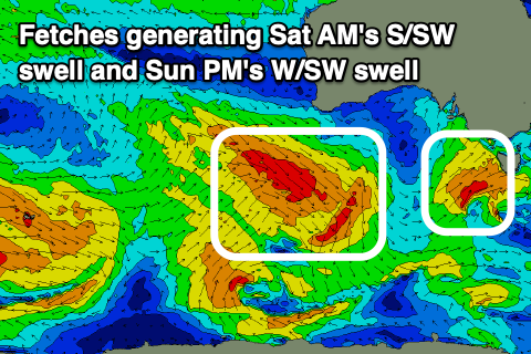
An inconsistent SW groundswell should be in around dawn, generated by a short-lived polar low, south-southwest of Western Australia earlier this week, but a building mid-period S/SW swell is on the cards for later in the afternoon and Saturday morning, produced by the front bringing Friday's change.
A bit more size to 3ft is due Friday afternoon, easing from 3ft+ Saturday morning, while the Mid Coast looks to remain tiny and to 1ft. Note the models are combining the mid-period swells and over-forecasting the size.
Conditions will be much better on Saturday as another approaching front brings moderate to fresh N/NW tending stronger NW winds, choppy on the Mid Coast.
Sunday will start smaller and with persistent NW winds, shifting more N/NW later into the afternoon as a new mid-period W/SW swell starts to fill in.
The source of this swell and a follow up increase from the SW Monday afternoon will be a pre-frontal fetch of strong to gale-force W/NW winds moving under WA Friday, with a broader and better aligned fetch of W/SW winds generating the SW component.
 Size wise, Sunday afternoon's pulse should kick back to 3ft across Middleton with tiny 1-1.5ft waves on the Mid Coast, similar in size Monday morning ahead of the slightly better SW swell late in the day.
Winds will remain fresh to strong from the N/NW on Monday, shifting W/NW mid-afternoon ahead of a late change.
The source of this change is a deepening mid-latitude low pushing in from the west and this will stall across the south-east of the country, bringing poor, strong S/SE winds into Wednesday and Thursday along with a stormy S'ly windswell.
We'll go over this in more detail on Friday though.
Comments
Hi Craig what size are you forecasting for Sunday morning?
cheers
Looks to be 2ft+ Middleton with 3ft sets at Goolwa.
thanks Craig