Plenty of surf days for the South Coast

South Australian Surf Forecast by Craig Brokensha (issued Wednesday May 19th)
Best Days: Late tomorrow South Coast, South Coast Friday through Tuesday, Mid Coast Sunday
Features of the Forecast (tl;dr)
- Small tomorrow AM with NW-N/NW winds, tending variable with a mix of new swells showing late
- Better Fri as the swells peak along with a moderate N/NE tending E/NE breeze
- Easing surf with moderate to fresh N/NE tending variable winds Sat, new steadying SW swell for the PM
- New W/SW swell building Sun with fresh N/NE-NE winds, easing Mon with strong N/NE winds
- Mod-large W/SW groundswell for Tue but with strong NW tending W winds
Recap
Great surf down South yesterday with solid 4-5ft sets out of the S/SW, dropping slowly through the day after peaking later Monday when the groundswell arrived. Conditions were favourable all day and the Mid Coast saw pulsey 1-1.5ft sets on the favourable parts of the tide for the desperate.
Today conditions are again great down South with smaller 2-3ft waves left across Middleton, a sloppy and weak 1ft on the Mid Coast with some N/NW windswell contamination.
This week and weekend (May 20 - 23)
We'll see the surf continuing to ease in size through this afternoon and evening, bottoming out tomorrow morning with a moderate to NW-N/NW breeze, tending variable into the afternoon. Middleton looks to be around 2ft on the sets, tiny on the Mid Coast, but later in the day our mix of building swells should be seen.
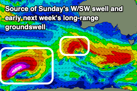
The first and best of the swell sources has been upgraded, with a tight though expanding polar low under WA generating a touch stronger and longer-lived fetch than forecast on Monday.
A great fetch of W/SW gales projected through our south-western swell window, south of WA yesterday and this should provide a late kick tomorrow to 2-3ft across Middleton and 1ft on the Mid Coast, peaking Friday morning to 3-4ft across Middleton, 1ft+ on the Mid Coast.
The close-range swell looks minimal with a deepening low tracking too quickly east and forming late in our swell window, to our south tomorrow. A brief burst of strong to gale-force W/SW winds are expected behind the low, but the swell from this will be under the energy from the polar low.
Looking at the winds for Friday and a moderate N/NE breeze is due through the morning, swinging E/NE into the afternoon with E/NE tending N/NW and then variable winds on the Mid Coast.
Saturday looks great all day as the mix of swells ease, likely from 2-3ft across Middleton under a moderate to fresh N/NE tending variable breeze.
 Into Sunday our new W/SW swell is still on the cards, with an initial strong but unfavourably aimed pre-frontal fetch of strong to gale-force NW gales producing a glancing SW swell for later Saturday and Sunday down South.
Behind this though a tighter fetch of similar strength W/SW winds should generate a new W/SW swell for Sunday but only to 3ft on the sets across Middleton and 1-1.5ft on the Mid Coast (with 2ft sets possible on the favourable parts of the tide). Winds will freshen but hold from the N/NE-NE all day, likely variable on the Mid into the afternoon creating fun options across both regions. Stronger N/NE winds are then due Monday as the mix of swells back off from 2ft across Middleton and 1ft on the Mid Coast.
Into Tuesday, a good, long-period W/SW-SW groundswell is due to fill, generated by a strong polar low firing up around the Heard Island region tomorrow morning.
This will be in our far swell window but with storm-force W/SW winds projected towards us until Friday afternoon, weaker but moving more into our western swell window on the weekend, we should see a moderate-large sized, long-period swell generated.
The remnants of the low will project up into WA and then the Bight, resulting in the formation of a slow moving mid-latitude low that will squeeze a strong high in the Tasman Sea as it moves east. This will bring strong NW tending W-W/NW winds as the swell fills in, but we'll have a closer look at this Friday. Size wise Middleton looks to reach 4-5ft+ with 3-4ft surf on the Mid Coast, mixed in with local windswell.