Large, easing surf on the weekend

South Australian Surf Forecast by Craig Brokensha (issued Friday April 23rd)
Best Days: South Coast every morning until Wednesday, keen surfers on the Mid Coast tomorrow AM
Features of the Forecast (tl;dr)
- Easing, large S/SW groundswell Sat with W/NW-NW tending SW winds (variable E on the Mid), smaller Sun with similar winds
- Mid-period S/SW swell Mon with N/NE tending SE winds, smaller Tue with similar winds though weaker sea breezes
- Small W/SW swells late next week
Recap
Average, sloppy waves on the Mid Coast yesterday, clean and to 2-3ft across Middleton in the morning, building through the afternoon but with bumpy/choppy conditions.
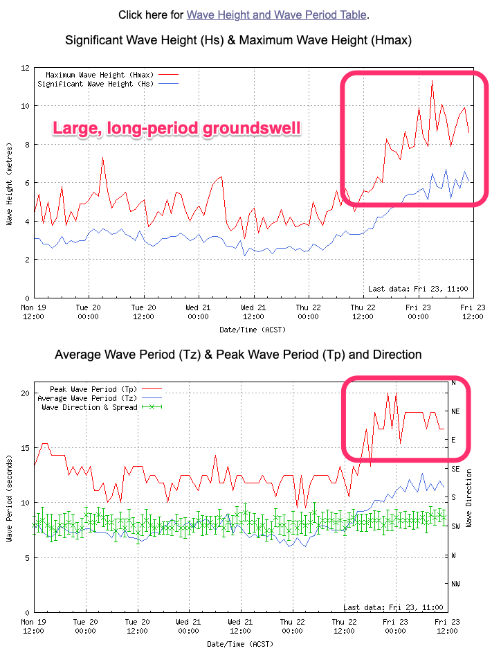
Today we've seen our large SW groundswell peaking with 6-8ft surf across the Middleton stretch, larger on the deep water reefs and exposed breaks. Winds were OK early but have since shifted more onshore creating bumpy conditions, with 1-2ft sets on the Mid Coast.
This weekend and next week (Apr 24 - 30)
Today's large, long-period SW groundswell will hold all day before tailing off slowly over the weekend. The slow easing trend is a result of the prolonged nature of the low and a secondary strong front that pushed up and on the backside of it.
Tomorrow morning will still be large and easing back from an easy 6ft across Middleton, 1-1.5ft on the Mid Coast and winds will become lighter and from the W/NW-NW during the morning down South, E'ly on the Mid ahead of moderate sea breezes.
Sunday should still see good sized sets, easing from 3-4ft across Middleton and 1ft on the Mid Coast. Similar winds are due across both coasts ahead of moderate sea breezes.
The surf should continue to ease in size and power through Monday, but a reinforcing pulse of mid-period S/SW swell is due down South, generated by weak polar frontal activity pushing up towards Tasmania tomorrow.
Sets to 3ft are due across Middleton, easing through the afternoon, down from 2-3ft Tuesday and 2ft max Wednesday.
Winds will swing around to the N/NE on Monday morning ahead of SE sea breezes, similar Tuesday but sea breezes will be weaker and suppressed, N/NW tending S Wednesday.
Longer term theres nothing significant on the cards but some small W'ly swell is likely late week from mid-latitude frontal activity in the south-east Indian Ocean.
Size wise the Mid Coast doesn't look to top 1-1.5ft with small waves down South. Winds look favourable and from the N each morning though.
Beyond this there's a bit of mid-latitude storm activity due into next weekend and early the following week, likely bringing windy onshore swells. More on this Monday though. Have a great weekend!