Lighter winds and fun swells

South Australian Surf Forecast by Craig Brokensha (issued Wednesday January 20th)
Best Days: South Coast magnets tomorrow morning, Saturday, Sunday and Monday mornings down South, Mid Coast for the keen Tuesday
Features of the Forecast (tl;dr)
- Easing S/SW swell with light morning winds
- New, inconsistent SW swell for Sat AM, with a S/SW groundswell for Sun AM with morning NE winds
- Tiny W/SW swell for the Mid Tue with morning S/SE winds
Recap
Nothing of note on the Mid Coast and a bit of swell down South, especially this morning but with persistent onshore winds and choppy/sloppy conditions.
This week and weekend (Jan 21 - 24)
The currently S'ly pulse will ease back steadily from this afternoon, more so into the evening and tomorrow as a result of the 'bombing low' linked to it forming late in our swell window, then pushing east under Tasmania.
Conditions will improve further though with a light, variable N'ly wind due tomorrow morning ahead of sea breezes. Size wise, expect easing 2ft sets across Middleton, bigger at Waits and Parsons, tiny into Friday morning. The Mid will be flat.
Friday morning should see variable winds again, but with the swell bottoming out, limited options for a decent surf.
Later in the day Friday but more so Saturday a new, inconsistent SW groundswell is due, with a stronger S/SW groundswell due later in the day and Sunday morning.
Saturday morning's swell has been generated by a relatively weak low that developed east of Heard Island earlier this week, with it still generating a fetch of healthy W/NW winds in our swell window, south of WA today.
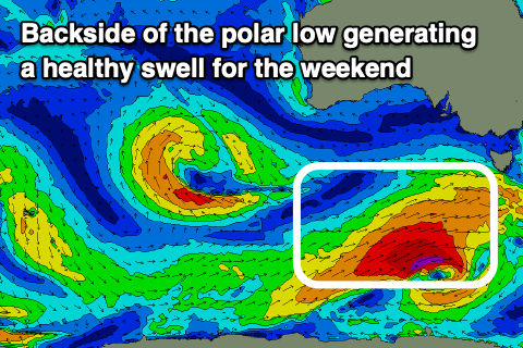 Behind this though, a front come low will generate a pre-frontal fetch of W/NW gales, followed by a better W/SW fetch of gales, just within our southern swell window Friday.
The first, inconsistent pulse for Saturday morning should offer good 3ft sets across Middleton, with the S/SW groundswell arriving very late in the day, peaking Sunday morning with 3ft+ sets, easing through the day.
The Mid Coast will fail to see any size again owing to the southerly direction of the swell.
Winds should be favourable each morning down South with a morning NE offshore Saturday ahead of S/SE sea breezes, similar Sunday, though winds may tend N/NE for periods. Monday should see a great N/NW offshore through the morning ahead of a trough but the swell will be easing from a small 2ft across Middleton.
 Longer term there's nothing major on the cards for the South Coast with a deepening surface trough to our south-east likely to squeeze a strong high, bringing a stormy increasing in S/SE windswell late week/next weekend, but more on this Friday.
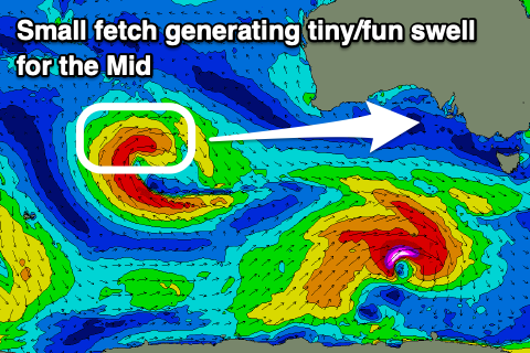
The Mid Coast should see a tiny, inconsistent W/SW groundswell Tuesday from a slow moving and not overly well structured mid-latitude pushing slowly east through the Indian Ocean over the coming days. A slim fetch of W'ly gales will be projected through our swell window, with the swell due to offer 1-1.5ft sets Tuesday (possibly 2ft sets on the magnets). Winds will hopefully be S/SE Tuesday morning, but again check back here Friday for more details.