Get stuck in before the sou'easters do

South Australian Forecast by Craig Brokensha (issued Friday 11th December)
Best Days: Selected spots South Coast tomorrow morning, Sunday South Coast, Monday morning South Coast
Recap
Nothing to surf on the Mid Coast with the swell coming out of the south the last two days, building through yesterday down South while mixed in with a localised windswell. Today is a decent size with a mix of peaking mid-period S/SW swell and localised S/SE windswell but conditions are poor with fresh cross-shore E/SE winds.
Also: Tim Bonython's ASMF is rolling through town, featuring 5 jaw-dropping films that capture the world's best big wave surfers battling the biggest waves on the planet. It's one to see on the big screen. Click here for the Noarlunga show next Tuesday: https://swllnt.com/2W5dApc And Mercury Adelaide on Saturday: https://swllnt.com/341bN8W
This weekend and next week (Dec 13 - 18)
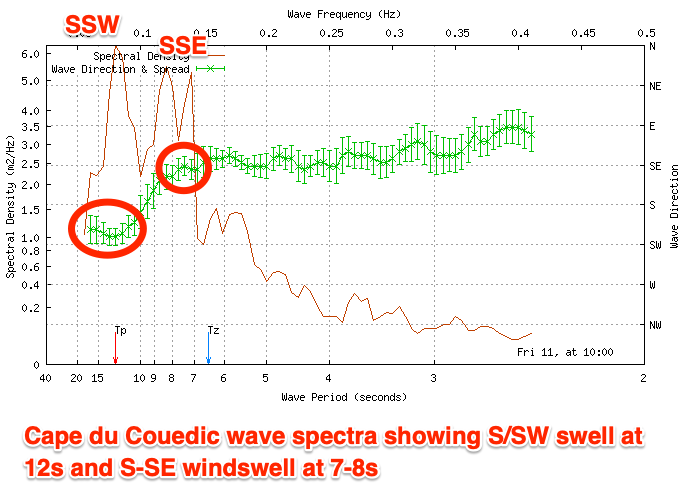
Today's mix of mid-period S/SW swell and S/SE windswell (shown on the Cape du Couedic wave spectra above) will ease in size over the weekend, though slowed a little tomorrow by a reinforcing, smaller S/SW swell.
This and a third pulse of S/SW groundswell due later Sunday are being generated by a conveyer belt of polar frontal systems swinging down from a position south-west of Western Australia, along the polar shelf and then up just east of Tasmania, around the bottom of a strong high.
This is just within our southerly swell window, with energy spreading radially up and into us from these sources.
The main positive for the coming days is the improvement in local winds for the South Coast. Tomorrow will likely be peaky and best at spots that like an easterly breeze with a moderate to fresh E/NE-NE wind, giving into gusty afternoon E/SE winds. Size wise Middleton should ease from 2-3ft, flat on the Mid Coast.
Sunday morning should be cleaner with a moderate to fresh NE-N/NE offshore, swinging N/NW into the afternoon though the swell will be small in the morning and only to 2ft on the sets across Middleton, flat on the Mid.
The new S/SW groundswell for the afternoon (generated by severe-gale NW winds aimed toward the polar shelf last night and today), should build to an inconsistent 3ft on the sets across Middleton later afternoon/evening and with that favourable offshore breeze.
Monday will then be smaller with the swell easing fairly steadily from 2ft to possibly 3ft along with morning N/NE winds ahead of a shallow afternoon SW change with a trough, possibly lighter W/SW into the evening.
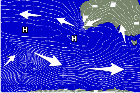 This trough will then be replaced by a strong high moving in from the west and from here it'll be game over for a while. It looks like the high pressure ridge will be our dominant synoptic feature at least until Christmas, stretching from south-west of us to under WA and into the Indian Ocean. This will bring poor S/SE-SE winds and along with no significant swell.
Any swell looks to arrive from weak, polar fronts and from the S/SW direction so the Mid will miss out as well. More on this Monday and in the meantime, make the most of the weekend!