Good swell to end the week with winds from all directions

South Australian Forecast by Craig Brokensha (issued Wednesday 28th October)
Best Days: South Coast tomorrow ahead of the wind change, Mid Coast selected spots Friday, Mid Coast for the keen Saturday, South Coast for the keen Sunday morning
Recap
A very slight improvement in the surf yesterday morning down South with winds swinging more easterly and backing off a touch along with 2-3ft of sloppy S/SE windswell.
Today winds have shifted offshore from the NW but the swell has eased in size leaving weaker 2ft waves across the swell magnets. The Mid Coast has been tiny to flat the last two days.
This week and next (Oct 29 – Nov 6)
After the last couple of days average surf, we've got better options for a paddle, especially on the Mid Coast over the coming days.
 Late today we may see a new, long-period W/SW groundswell hitting the Cape du Couedic wave buoy, but the bulk of the swell is due to fill in tomorrow afternoon, holding through most of Friday before easing slowly on the weekend.
The source of this swell was a strong, long-lived frontal progression between Western Australia and the Heard Island region through the weekend and early this week. A slow moving fetch of gale to severe-gale winds were generated through our western swell window and we should see the surf build tomorrow, kicking strongly into the afternoon to 2ft on the Mid Coast, with 3ft sets more than likely, backing off to 2ft+ on Friday working the favourable parts of the tide.
The South Coast should build to 3ft+ across the Middleton stretch, though inconsistent, holding a similar size Friday morning.
Winds will unfortunately swing all over the shop for both coasts tomorrow as a surface trough moves through bringing a morning NE'ly, shifting N/NW-NW into the early afternoon and freshening then W/NW tending W/SW late. With this protected spots on the South Coast will be the pick as the swell builds.
Friday will be best for the Mid with strong S-S/SE winds, creating bumpy though workable waves ahead of S/SW sea breezes.
As we move into the weekend the size will slowly ease with inconsistent 1ft to possibly 2ft waves on the Mid Saturday with S/SE winds ahead of a S-S/SW sea breeze, and the South Coast will be poor with a mix of S/SE windswell to a choppy 3ft.
Come Sunday the South Coast should improve as winds tend E/NE through the morning but the surf will be small, peaky and weak, easing from 2ft or so across Middleton, tiny on the Mid Coast.
Monday/Tuesday will be cleaner down South but tiny.
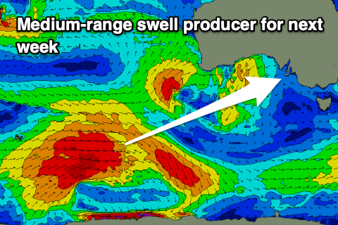 We then look towards the increase in activity through the Southern Ocean from this weekend through next week, with a broad node of the Long Wave Trough due to strengthen south-west of WA, pushing east while weakening.
This will cause a strong, broad polar low to develop around the Heard Island region, moving east while generating a fetch of W/SW gales in our medium-range south-western swell window. We'll even likely see core winds reach severe-gale, with the storm weakening while pushing slowly east next week.
An inconsistent, moderate sized SW groundswell is due, with it arriving late Wednesday, building Thursday ahead of a peak into the afternoon, then easing slowly Friday. Size wise it looks to come in around 4ft on the sets across Middleton with 1-1.5ft waves on the Mid Coast.
Winds look to favour the Mid as another trough moves through Wednesday, bringing a S/SE change, but more on this Friday.