Swells and winds from all directions

South Australian Forecast by Craig Brokensha (issued Monday 5th October)
Best Days: Mid Coast tomorrow afternoon for keen surfers, South Coast for the keen Thursday morning, similar in protected spots Friday morning, later Friday down South, Mid Coast Friday afternoon, both coasts on the weekend
Recap
Windy though decent sets across the Mid Coast Saturday with a good, reinforcing W/SW groundswell, cleaner down South and fun across the swell magnets. The Mid was cleaner Sunday and hanging in at 1-2ft, OK down South but deteriorating with a strengthening onshore wind.
Today the Mid Coast was back to 1-1.5ft and not the cleanest, poor down South with the onshore breeze.
This week and weekend (Oct 6 - 11)
 In the wake of the weekend's rain and change associated with a deep, moisture laden trough, we'll see a high move in, swinging winds around to the E/SE-SE tomorrow, slightly better and tending E-E/NE on Wednesday.
This will be along with a new mid-period S/SW swell, generated the last couple of days by a broad and healthy polar front projecting up towards Victoria from a position, south-southwest of WA.
The swell is due to fill in tomorrow and peak through the afternoon to 4ft+ across Middleton, while the Mid Coast looks to hover around 1-1.5ft, possibly reaching 2ft on select magnets with the favourable parts of the tide. This will be from a more favourably aimed fetch on the northern arm of the progression at mid latitudes.
The swell will ease Wednesday back from 4ft or so across Middleton and 1-1.5ft on the Mid Coast as winds and conditions try to improve down South. It'll be lumpy/peaky so keep your expectations low.
Thursday looks windy and from the opposite direction as a low forms across Victoria, bringing in strong W'ly winds, creating poor conditions on the Mid and OK waves in protected spots down South. The swell will be smaller again though and easing from 2-3ft down South, with a tiny windswell on the Mid Coast.
From Friday afternoon, into next week we've got some fun, inconsistent groundswell on the cards along with favourable winds as the storms stay at arms length from us, while a strong high sits to our north, squeezed by deepening inland troughs moving in from the west.
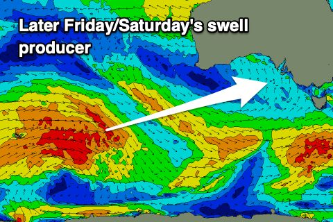 Looking at the swell and an initial inconsistent W/SW groundswell should build Friday afternoon, peaking Saturday morning, generated by a strong, slow moving Southern Ocean frontal progression that's currently around the Heard Island region. A broad fetch of W/SW gales will move slowly east while weakening today, with a secondary fetch of W/SW gales developing on its tail, closer to Western Australia.
It'll be inconsistent but the W/SW groundswell should offer infrequent 3ft sets across Middleton into Friday afternoon/evening, with the Mid Coast building to 1-2ft. Saturday should see the swell offering a touch more size to 3ft+ and 1-2ft respectively, easing Sunday.
Winds on Friday look N tending NW, with variable tending locally offshore winds on Saturday ahead of sea breezes. Sunday looks similar with local offshore E/NE winds ahead of sea breezes.
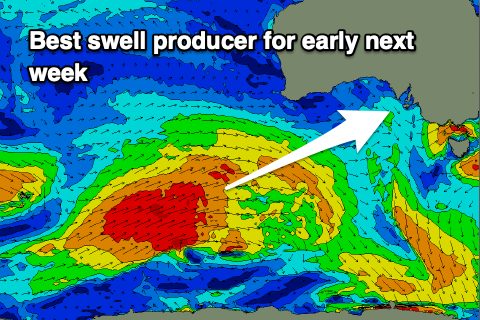 Into Monday a better SW groundswell is due across the state. The source of this swell will be a stronger, closer frontal progression moving in from the Heard Island region, weakening south of a position under Western Australia.
A moderate to large sized SW groundswell is due, filling in Monday and providing inconsistent 4-5ft waves down South, with inconsistent 2ft sets on the Mid Coast with those NE breezes. More on this Wednesday though.