Windy west swells over the coming days

South Australian Forecast by Craig Brokensha (issued Monday 21st September)
Best Days: Protected spots down South tomorrow and Wednesday morning, early Thursday down South, possibly Sunday morning for the keen down South
Recap
Good to great waves on the South Coast for the weekend with a fun S/SW groundswell and favourable winds. The Mid Coast was wind affected and tiny.
Today the swell has bottomed out down South along with strong and unfavourable NW winds, choppy on the Mid Coast with a building mix of low quality swells.
This week and weekend (Sep 22 – 27)
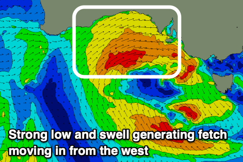
After the weekend's S/SW swell, out attention swings to the west with a slow moving and strong mid-latitude low currently edging in.
The low's generating a broad fetch of strong W/SW winds through our western swell window, with embedded bursts of gale-force winds and we'll see the low move in and across us proper this evening.
 Tomorrow is then expected to see stormy 3-4ft waves on the Mid Coast, while the westerly direction will limit the size down South, likely coming in around 3ft at Middleton and 4ft towards Goolwa.
Winds will be strong out of the W/NW all day, favouring protected spots down South, then W/NW early Wednesday before shifting W/SW mid-late morning in the wake of the low.
The size looks to be on the ease with the Mid Coast dropping from a choppy 2-3ft max, 3ft+ or so down South but holding all day as a new S/SW swell fills in, generated on the backside of the low.
Thursday morning is probably the pick down South for slightly more exposed spots as the S/SW swell eases from 2-3ft along with a NW tending W/NW and then W/SW breeze. The Mid looks minimal and still bumpy with fading 1ft to maybe 2ft sets.
Moving into the end of the week and a strong cold outbreak will be projected up and over us Thursday evening and Friday, bringing cold, wet weather and strong onshore S/SW winds and a building S/SW windswell but with no quality to it at all.
The cold outbreak will form into a low across Victoria and be quite slow moving, leaving poor, onshore S/SW winds on Saturday as the S/SW windswell eases, possibly better and out of the E/NE on Sunday morning with 2-3ft of leftover S'ly swell.
The Mid Coast won't benefit much from, this system owing to the south in its direction.
Longer term, an upper level ridge moving in next week won't be conducive to generating any decent swell either, so all in all the current period isn't too flash.