Windy weekend with building surf

South Australian Forecast by Craig Brokensha (issued Friday 8th May)
Best Days: South Coast Sunday, both coasts Monday, South Coast Tuesday morning, Mid Coast Wednesday
Recap
Small to tiny waves across the South Coast yesterday while the Mid Coast saw a building windswell through the afternoon with strengthening onshore winds.
Today a large W'ly groundswell is in the water, but it's so west that it's not offering much size across Victor and performing best on the Mid Coast, but conditions are wind affected here. The swell hit a peak in wave heights of 12.1m at midnight, with Significant Wave Heights of 6.8m. The swell has settled back through the day though is still large with 3ft sets on the Mid Coast.
This weekend and next week (May 9 - 15)
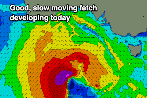
While the storm linked to today's large W'ly groundswell has since passed, we've got another approaching from the west-south-west. A mid-latitude front has spawned into a low south of Western Australia and we're seeing a good fetch of severe-gale SW winds projected slowly through our south-west swell window today.
 A front on the back of this low will push through tomorrow, with a mix of easing W'ly groundswell from today and new mid-period W/SW swell due tomorrow to 2-3ft across the Mid Coast, 2ft to occasionally 3ft off Middleton before possibly increasing later with the new groundswell.
The size for Sunday has been upgraded a touch with good sets to 4-5ft now expected off Middleton while the Mid Coast should persist around 2ft to occasionally 3ft on the favourable parts of the tide.
Winds are still looking average all weekend though and strong from the W/SW tomorrow (possibly W'ly at dawn around Victor), better Sunday morning down South and W/NW early before shifting W/SW though without much strength.
Monday still looks the pick for both coasts with a light NE breeze on the Mid, N/NW all day on the South Coast with the easing SW groundswell from 2ft on the sets across the Mid, 3ft+ off Middleton. The models are over-forecasting the size on the South Coast for Sunday and Monday so keep this in mind.
A low point in swell is due on Tuesday with NW tending W/NW winds ahead of a trough which will bring a S'ly change Wednesday.
A new W/SW groundswell will be seen on Wednesday though, the source being a frontal progression firing up west-southwest of WA on the weekend, projecting a fetch of W/SW gales through our medium-range swell window. The front will weaken when pushing under WA resulting in a moderate sized W/SW groundswell for Wednesday, best on the Mid with the S'ly winds and to 2ft+, 3ft+ across Middleton. We'll see this swell ease into the end of the week with winds from the south-east but more on this Monday. Have a great weekend!