Stormy, cold and windy days ahead

South Australian Forecast by Craig Brokensha (issued Wednesday 29th April)
Best Days: Protected spots over the coming days for experienced and keen surfers on the South Coast, both coasts Sunday morning, South Coast Monday morning
Recap
Great waves on the South Coast yesterday with plenty of size and offshore winds, strengthening a little into the afternoon as the swell eased. The Mid Coast was 1-1.5ft+ and OK at dawn but quickly deteriorated.
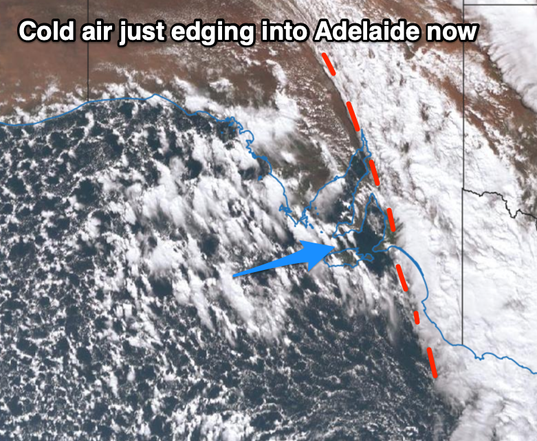
Today our new W/SW groundswell has filled in and conditions at dawn on the Mid were good with variable winds, but we've since seen fresher onshore breezes kick in as a cold air mass edges in from the west. This can be seen in the satellite image below with the speckled cloud mass behind the main front.
The South Coast was good with a lift in swell to 3-4ft across the Middleton stretch with light morning W/NW winds. Winds are due to play fairly nice all day and only be moderate W/SW-SW into this afternoon.
This week and weekend (Apr 30 – May 3)
We've seen the pre-frontal arm of a deepening and significant mid-latitude low move across the state bringing rain and now the cold air is about to move in.
A new W/SW swell is expected into this afternoon and tomorrow from this front, generated by a fetch of easing W/SW gales moving through the Bight the last two days.
We should see the Mid Coast kicking to 2-3ft, with the South Coast dropping back to 2-3ft due to how west the swell is and the shadowing effects of Kangaroo Island.
Local winds are an issue though with a strengthening SW breeze on the Mid, W/SW tending SW down South, so surfing options will be limited.
This strengthening onshore breeze will be linked to the low deepening south of the state.
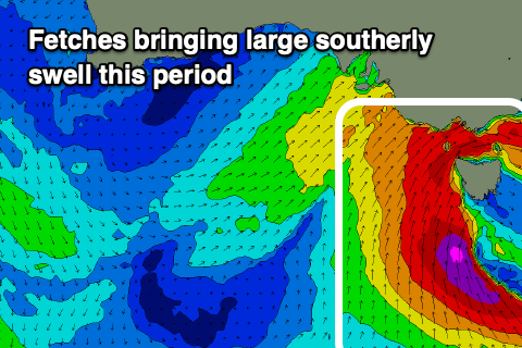 The weather models have converged on the positioning and slow movement of the low, but GFS is still showing stronger embedded winds around its core, which would result in larger surf.
Either way, we're expected to see a large, stormy S'ly swell building across the South Coast from Thursday and peaking through Friday, easing slowly from Saturday.
The Mid Coast won't see much in the way of quality due to the southerly direction and blocking effects of Kangaroo Island, with localised though sizey windswell being the main swell source of surf.
Looking at the expected size and we're likely to see Middleton building to 4-5ft tomorrow afternoon, larger and to 6ft+ through Friday. Later in the day and more so Saturday morning we may see 8ft sets in the mix, smaller and easing from 4-5ft Sunday. Check back Friday for a clearer idea on the expected peak in size.
The Mid Coast will see choppy 2-3ft waves Friday, easing back from 2ft Saturday, tiny Sunday.
Local winds will be poor for the whole event and string from the W/SW down South Friday more SW on the Mid Coast, with the outside chance for an early W'ly around Victor. Saturday looks to play out very similar with Sunday seeing lighter S'ly winds down South, workable for the keen and clean on the Mid.
Monday should see winds go back offshore from the N/NE with a fun amount of easing S'ly swell.
Longer term there's nothing significant on the cards for next week until late in the week, but more on this Friday.
Comments
Was great to see so many old faces out at the bowl earlier this arvo, I felt like I was in a midcoast time warp back to the 90's!