Increasing swell activity through next week, though winds will remain tricky

South Australian Forecast by Craig Brokensha (issued Friday 21st February)
Best Days: Sunday morning South Coast swell magnets, Monday morning South Coast, Tuesday morning South Coast, Thursday morning South Coast
Recap
Tiny but clean 1-1.5ft waves across the Mid Coast most of yesterday for bigger boards and beginners, tiny to flat today. The South Coast has remained poor with an easing mix of groundswell and windswell yesterday, mostly the later today.

This week and weekend (Feb 22 - 28)
We'll see a slow improvement in surface conditions down South over the weekend, but with no decent groundswell.
A mix of background swell and S/SE windswell only look to offer 1-2ft sets off Middleton max tomorrow and Sunday, flat on the Mid Coast.
A morning E/NE breeze will create peaky and OK conditions tomorrow, cleaner and better Sunday with a N/NE offshore. Hit the swell magnets for a small wave but keep your expectations low.
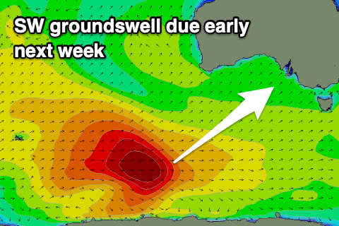 Moving into next week and we've got a lot more swell activity on the cards, firstly in the form of an inconsistent, long-period SW groundswell mixed in with some mid-period S/SW energy on Monday, easing Tuesday.
A strong but distant polar low generated the long-period energy mid-week, with the remnants of this low now generating a broad fetch of strong W/SW winds while continuing slowly east, well south of WA today, weakening further over the weekend.
This will produce some more consistent mid-period energy in between the long-period sets out of the S/SW, with both filling in Monday peaking through the middle of the day/afternoon. There might be a hint of swell later Sunday but Monday should see sets building to 3-4ft across Middleton but only 1ft on the Mid Coast. The swell should ease into Tuesday from 3ft+ across Middleton and tiny on the Mid again and to 0.5-1ft.
Looking at the local winds and we'll hopefully see a light E'ly on Monday morning, not great but also not too bad, shifting more onshore through the day, while Tuesday morning looks to see lingering onshore S'ly winds, not great again but workable.
As touched on in Wednesday's notes, a strengthening node of the Long Wave Trough will move in from the west next week, bringing with it a flurry of increased polar frontal activity.
All this activity will be focussed mostly towards Victoria and as a result winds will be more from the southern quadrant than western and the swells out of the SW-S/SW. Size wise we're looking at moderate mounts of swell, possibly larger later week but we'll have a closer look a this Monday.
Have a great weekend!