Weak swells easing over the weekend, new swell mid-week

South Australian Forecast by Craig Brokensha (issued Friday 11th October)
Best Days: Swell magnets tomorrow morning, Wednesday morning, protected spots South Coast Thursday morning
Recap
An improvement in conditions across the South Coast yesterday, though best at spots that like a north-east breeze, poor today with winds not as favourable and a mix of sloppy swells.
The Mid Coast backed off to a tiny 0.5-1ft yesterday, effectively flat today.
This weekend and next week (Oct 12 - 18)
These notes will be brief as Ben's on annual leave.
We'll see cleaner conditions on the South Coast tomorrow morning and this will be the pick of the weekend, best on the swell magnets with a mix of easing S/SW swell and S/SE windswell.
Size wise Middleton only looks to be a small 1-2ft or so, better and to 2-3ft at Waits and Parsons.
A morning NE-E/NE breeze should create OK conditions before sea breezes kick in, cleaner Sunday with a more N/NE breeze but the surf will be tiny. There might be tiny 1ft waves out of the W/SW on the Mid Coast Sunday, but only suitable for beginners.
 There's nothing significant due into early next week, with background swell energy generated in our far swell windows and having no size to it at all. Therefore the South Coast is due to remain tiny with an early W/NW breeze Monday before shifting onshore, E/NE-NE Tuesday morning.
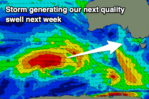
The next considerable swell is due to arrive very late in the day Tuesday but more so Wednesday, as talked about last update. This swell will be produced by a distant polar low forming around the Heard Island region last night, generating a fetch of severe-gale W/SW winds, expanding in scope while projecting east-northeast towards WA, a bit more into our western swell window.
The storm will break down south of WA on Sunday but then continue slowly east-southeast through our south-western swell window in a much weaker form early next week, generating some reinforcing SW swell for Thursday, but only mid-period.
Size wise the Mid Coast should see fun 2ft sets, with 3-4ft waves off Middleton and winds are now looking better and most likely variable in the morning, shifting S/SW with an approaching front.
We may see winds vary from W/SW to the W/NW through the day Thursday with a stronger front as the swell eases, but more on this Monday.
Longer term a significant polar frontal system is forecast to develop south of the country later next week by both ECMWF and GFS, generating what at this stage looks to be moderate to large S/SW groundswell for next weekend. A high looks to move in bringing unfavourable S-S/SE winds, but again, more on this Monday. Have a great weekend!