Workable weekend as winds do a full 180

South Australian Forecast by Craig Brokensha (issued Friday 4th October)
Best Days: Saturday, Sunday protected spots South Coast
Recap
Poor conditions on the South Coast yesterday with onshore winds and a small swell, with the new S/SW groundswell pulsing into the afternoon but a little under forecast expectations. The Mid Coast was tiny in the morning but a new W/SW swell provided 1-1.5ft sets into the afternoon with weak onshore winds.
Today the surf is small and average on the South Coast again but cleaner, tiny on the Mid Coast.
This weekend and next week (Oct 5 - 11)
The inconsistent and long-period W/SW groundswell due tomorrow across the state impacted Western Australia yesterday and is still large this morning, with it due to arrive across our region later today and peak through tomorrow. The new Cape du Couedic spectral analysis has actually picked up the long-period signal so it's on the way.
It'll be inconsistent with long waits for sets to the 3-4ft range between Middleton and Goolwa, while the Mid Coast should come in at 2ft on the swell magnets on the favourable parts of the tide.
Winds will be favourable for both coasts with a fresh E/NE'ly on the Mid, NE on the South Coast and persisting all day.
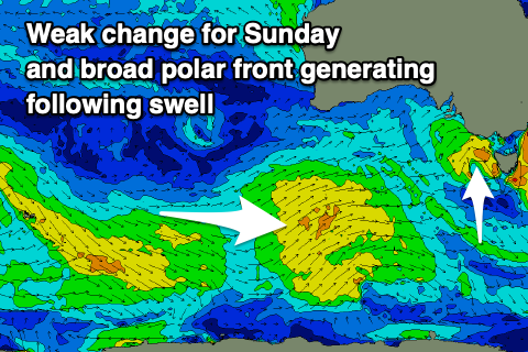
Come Sunday the swell is expected to ease, slowed a little by polar frontal activity that's currently skirting around our southern swell window.
Easing 2-3ft sets are due off Middleton with strong but easing W/NW winds ahead of a late W/SW change, with choppy and bumpy 1ft to occasionally 2ft waves on the Mid.
 The mid-latitude low isn't expected to generate any real additional swell with weak easing waves Monday from 1ft+ on the Mid Coast and 1-2ft down South with a W/NW tending W/SW breeze.
We've got some fun mid-period SW tending S/SW swell on the cards for Tuesday through Thursday next week as a couple of relatively weak but in the first case, slow moving polar frontal systems project up and towards us through the weekend, more polar in latitude early next week.
Unfortunately a slow moving high in the wake of a change Monday will see average S/SW winds Tuesday as the best SW swell fills in, more SE into Wednesday as the swell eases a little, with a reinforcing S/SW pulse for Thursday with better E/NE winds.
Size wise, the Mid Coast isn't due to see too much size with Tuesday the best and offering 1-1.5ft+ waves, and a late S/SE breeze, tiny thereafter.
Longer term a deepening inland surface trough through WA will put a block on our swell windows, resulting in easing surf into Friday and Saturday ahead of a change in the weather through next weekend. More on this Monday. Have a great weekend!