Small W/SW swells all week, windy and larger Friday

South Australian Forecast by Craig Brokensha (issued Monday 2nd September)
Best Days: Possible Mid Coast late tomorrow, both coasts Wednesday and early Thursday
Recap
Good waves across the swell magnets on the South Coast Saturday, on the small to tiny side Sunday.
A new W/SW swell expected on the Mid Coast Saturday failed to show with flat conditions reported, while Sunday saw a tiny increase in swell but average conditions.
Another less consistent but better pulse of W/SW groundswell today looks to not have come in as expected either with inconsistent and tiny 1-1.5ft waves across the gulf. The South Coast was nice and clean again and best on the swell magnets with excellent glassy conditions.
Today’s Forecaster Notes are brought to you by Rip Curl
This week and weekend (Sep 3 - 8)
With today's best W/SW swell not quite coming to play, we've got a couple more opportunities for a wave on the Mid Coast this week, owing to constant but weakening mid-latitude fronts pushing up and across WA and then east-southeast through our western swell window.
This isn't ideal for swell generation with generally small surf around the 2ft range off Middleton and ebbing and pulsing around 2ft on the Mid Coast.
Tomorrow morning looks to be a low point in between swells with tiny 1ft waves on the Mid, 1-1.5ft off Middleton, but a new mid-period W/SW swell is due into the afternoon. 1-2ft sets will hopefully be seen by late in the day on the Mid, but Wednesday afternoon/Thursday are looking more reliable when a slightly better W/SW swell fills in.
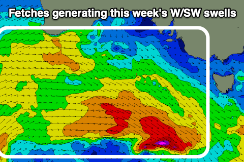 This will be generated by a weak front producing a fetch of W/SW winds under WA tomorrow, providing more consistent 2ft waves on the Mid Coast. Middleton looks to 2ft sets Wednesday afternoon and Thursday morning.
Winds tomorrow should be variable on the Mid Coast early, but then onshore into the afternoon from the NW but without much strength, W/NW most of the day down South.
Wednesday looks favourable for both coasts with a N/NE breeze on the Mid, variable late afternoon and N/NW ahead of sea breezes down South.
We'll hopefully see variable breezes again Thursday morning on the Mid ahead of an increasing W/NW breeze and this looks to be the pick with the best swell. Middleton should be fun as well with a N'ly offshore tending W/NW breeze.
Moving into the end of the week, a deepening mid-latitude low is expected to form south-west of us, though the models diverge on the movement, timing and intensity. We've just got one more model update coming in now and it looks like GFS is converging with the ECMWF solution and slowing the movement of the system and intensifying it over us.
This will see strengthening W/SW winds into Thursday evening and Friday as the low pushes up and across us, tending S/SW through the day.
A stormy 3ft of swell is expected on the Mid Coast, tiny down South ahead of an afternoon increase in S/SW windswell to 4ft or so.
The low will slowly move off to the east through the weekend with easing levels of windswell though no additional groundswell of significance at this stage.
Onshore S/SW winds look to persist Saturday across both coasts, back to the W/NW on Sunday. There's the possibility of a new S/SW groundswell on Sunday for the South Coast but ECMWF isn't interested in the polar storm generating it. So we'll have another look at this and the outlook for late week again on Wednesday.