Great run of waves for the South Coast with a large swell next week

South Australian Forecast by Craig Brokensha (issued Wednesday 17th July)
Best Days: Mid Coast late Friday, South Coast ever day this period, smallest tomorrow
Recap
A drop in swell and tiny glassy waves on the Mid Coast yesterday, increasing a tad today but choppy and onshore. The South Coast was solid and good in protected spots yesterday morning, average into the afternoon with a gusty SW breeze.
This morning we’ve got cleaner conditions again and waves ranging between 3-4ft along the Middleton to Goolwa stretch, best in slightly protected spots.
Today’s Forecaster Notes are brought to you by Rip Curl
This week and weekend (Jul 18 - 21)
These notes will be short as Ben's on annual leave.
As touched on in Monday’s notes, tomorrow will be a touch smaller again on the coast with the models incorrectly combining a mid-period and small long-period swell.
We’ll likely see 2ft+ waves across the Middleton to Goolwa stretch and tiny waves on the Mid with a persistent and moderate to fresh NW breeze.
Our W/SW groundswell for Friday and Saturday morning is still on track, with a strong mid-latitude front that’s currently pushing under WA, generating a fetch of strong W/SW winds, with embedded gales.
We’ll see the swell build through Friday and reaching 1-2ft on the sets across the Mid Coast into the afternoon and 3ft off Middleton late afternoon. A drop in size from a similar range is expected on Saturday morning, much smaller into the afternoon.
Conditions will remain great for the South Coast with a N/NW tending N’ly breeze Friday (aim for the late with the new swell) and fresher N-N/NW winds on Saturday. The Mid Coast will likely be best later Friday with N/NE winds all day, N’ly for a period into the afternoon.
 On Saturday evening a tight and deepening trough/low is likely to produce a short-lived increase in W/SW swell for both coasts Sunday. We’re only talking 1-2ft on the Mid Coast and 2ft off Middleton with 3ft sets towards Goolwa along with freshening NW winds.
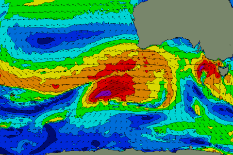
Longer term a significant mid-latitude frontal progression is forecast to develop south-west of WA on the weekend (pictured right), with an elongated fetch of severe-gale to storm-force W/SW winds currently forecast to be projected towards us. This will generate a large, long-period W/SW groundswell for Tuesday, building later Monday along with gusty W/NW winds. We’ll have a closer look at this on Friday.