Improving and fun run for the South Coast

South Australian Forecast by Craig Brokensha (issued Friday 12th July)
Best Days: South Coast protected spots tomorrow morning, Wednesday morning, Thursday morning, Friday, Saturday and Sunday morning, Mid Coast Friday afternoon
Recap
Onshore and sloppy 2-3ft waves on the Mid Coast Saturday with a drop in swell from Friday, smaller and to 1-2ft yesterday, similar today with weaker onshore winds.
The South Coast was large and onshore on Saturday with limited options for a decent wave, smaller yesterday and better in protected locations. Today another large S/SW groundswell is filling in but with poor conditions and 6ft sets but onshore winds.
Today’s Forecaster Notes are brought to you by Rip Curl
This week and weekend (Jul 16 – 21)
These notes will be short as Ben's on annual leave.
The coming week will see plenty of fun sized waves for the South Coast and with favourable winds, best from Wednesday.
Today's large S/SW groundswell will ease tomorrow, mixed in with a smaller long-period signal from the earlier stages of the low that generated it, and some mid-period S/SW swell from a front passing under us today.
Size wise, Middleton looks to ease back from 4-5ft for the most part off Middleton, with possibly the odd 6ft'er still in the mid, tiny and 1-1.5ft on the Mid Coast.
Winds should tend W/NW around Victor for a period tomorrow morning before reverting back to the SW. The Mid Coast looks to see more variable onshore winds and OK conditions but no size.
 The swell will ease back further Wednesday from 3ft off Middleton with a W/NW breeze holding all morning, shifting W/SW mid-afternoon.
Thursday is showing an uptick in size, but this doesn't look to be the case with the models incorrectly combining swells. Instead Middleton looks to hold around 2ft, with better waves out Waits way in the morning with a moderate to fresh NW breeze, shifting less favourable and stronger W/NW into the afternoon with an approaching front.
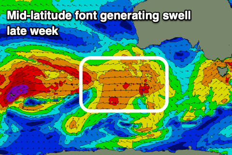
This frontal progression looks good, with a fun and moderate sized W/SW groundswell due to build Friday and ease Saturday. This progression will develop west-southwest of WA tomorrow afternoon, with a broad fetch of strong to near severe-gale W/SW winds forecast to move under the country, onwards across Tassie on Friday.
The swell should build Friday and reach 2ft on the Mid Coast into the afternoon, building to 3ft to maybe 4ft off Middleton, with easing sets from the same size Saturday morning.
Winds will be more favourable for the Mid Coast with a N'ly breeze creating some bumps, but not totally ruining the surf, while the South Coast looks to see variable tending N/NW winds, creating great conditions. A fresher N'ly tending N/NW wind on Saturday will continue to create excellent waves down South, while the Mid Coast will become choppy and poor.
Longer term we've got a decent SW groundswell on the cards for the middle of next week, though a trough moving in later Sunday may spoil winds locally for the South Coast. More on this Wednesday though.
Comments
Hows it looking for yorkes sat/sun?