OK weekend in protected spots, very large swell next week

South Australian Forecast by Craig Brokensha (issued Friday 24th May)
Best Days: South Coast protected spots Saturday and Sunday morning, Tuesday morning, novelty breaks Wednesday, Mid Coast for keen surfers from Sunday
Recap
A slow start to the Mid Coast yesterday with clean 1-1.5ft waves, but with the incoming tide and a new W/SW groundswell swell magnets pulsed to a great 2ft to occasionally 3ft with light winds and glassy conditions. The South Coast was also great all morning, a little bumpy at more open spots into the afternoon as winds shifted more westerly.

This morning the Mid Coast was back to 2ft and bumpy with a northerly wind, great down South with a bit more size to 3ft off Middleton and offshore winds.
Today’s Forecaster Notes are brought to you by Rip Curl
This weekend and next week (May 25 – 31)
The South Coast should maintain 3ft+ sets off Middleton tomorrow morning with a reinforcing SW swell due to fill in this evening, easing into tomorrow afternoon.
 With the swing in direction more to the SW, The Mid Coast looks to drop back to a less consistent 1-2ft but W/NW tending W/SW winds will favour protected spots down South, bumpy everywhere else.
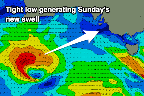
A reinforcing W/SW-SW swell for later in the day Saturday and more so Sunday morning has been upgraded slightly, with the tight low linked to it due to maintain its strength as it passes under us tomorrow. A fetch of W/SW gales through our western and then south-western swell windows should see the Mid Coast pulse back up to 2-3ft, with 4ft sets off Middleton.
Winds will remain fresh from the W/NW-W creating average conditions on the Mid, cleanest in protected spots on the South Coast Sunday morning.
Our secondary system tracking in on the tail of the original storm looks to generate an additional fetch of strong to gale-force W/SW winds in our south-western swell window on Sunday, producing a further boost in mid-period swell for the afternoon, easing Monday.
Middleton may see the odd set above 4ft, easing from a similar size on Monday, with the Mid Coast easing from 2-3ft. Winds unfortunately look onshore across all locations Monday in the wake of Sunday's front, fresh from the SW.
On the back of Sunday's front we'll see a significant polar frontal system forming south of the country on Monday with a broad and elongated fetch of severe-gale SW winds being initially projected towards us, before becoming more stretched out and reaching storm-force in our southern swell window on Tuesday. This core storm-force S/SW fetch will slowly project towards the south-east of the country, on top an active sea state before the low continues east and out of our swell window on Wednesday.
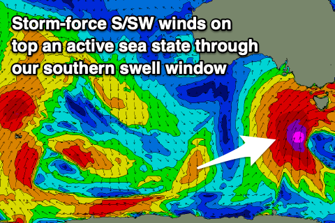 We'll see a very large, long-period and S/SW groundswell event building Tuesday ahead of the largest pulse on Wednesday and likely into the afternoon.
The South Coast looks to start around 3ft off Middleton Tuesday morning, building rapidly towards 5-6ft later in the day, with the Mid Coast coming in around 2ft, while Wednesday will become very large as sets push towards 8-10ft right along the coast. With the S/SW direction the Mid Coast looks to maintain 2ft surf.
Winds will be an issue on both coasts though with a gusty early W'ly breeze Tuesday morning due to strengthen from the W/SW through the day, with strong SW winds on Wednesday.
Unfortunately winds look to linger from the S'th as the large surf eases into the end of the week, owing to the slow moving nature of the Long Wave Trough east. More on this Monday though. Have a great weekend!