Very active period with varying winds

South Australian Forecast by Craig Brokensha (issued Wednesday 6th March)
Best Days: Both coasts tomorrow, South Coast Friday morning, Saturday morning and Sunday morning, Mid Coast late Tuesday and experienced surfers South Coast, similar Wednesday morning
Recap
Clean tiny 1-1.5ft waves on the Mid Coast yesterday, with a variable breeze and lumpy 2ft waves for keen surfers on the South Coast before stiffer sea breezes kicked in.
Today a large and strong SW groundswell has filled in with poor onshore wind across the South Coast, small and bumpy on the Mid Coast with sets to 2ft. Winds are due to swing S/SE later on the Mid Coast, cleaning up the surf with sets hanging around at 2ft.
Today’s Forecaster Notes are brought to you by Rip Curl
This week and weekend (Mar 7 - 10)
Today's strong long-period SW groundswell should start easing through tomorrow but conditions will be great across all locations. A morning NE-N/NE breeze is due to tend more NW and variable into the afternoon, with easing 4-5ft sets from dawn along the Middleton stretch. The Mid Coast should see NE tending variable winds and easing 2ft sets (mostly 1-2ft).
Friday will be clean again but the swell much smaller and easing from 2-3ft off Middleton, tiny on the Mid Coast with a N'ly offshore, giving into a shallow SW change mid-afternoon. Hit the magnets for the most action.
 Our new S/SW groundswell for Saturday is still on track, though a touch smaller in size, with a strong and intense low forecast to develop later in our swell window, south of the Bight tomorrow.
A tight and strong fetch of severe-gale to storm-force W/SW winds will be aimed through our southern swell window , producing a good S/SW groundswell Saturday to 3-4ft off Middleton (possibly rare bigger one), easing through the day. The Mid Coast will remain tiny and around 1ft.
Winds look favourable for the South Coast and variable out of the W/NW through the morning, SW into the afternoon as the swell eases, clean again Sunday with shifting winds from E/NE to W/NW as a cold front moves in from the west. Size wise we'll be looking at easing 2-3ft sets, smaller into Monday morning.
Next week (Mar 11 onwards)
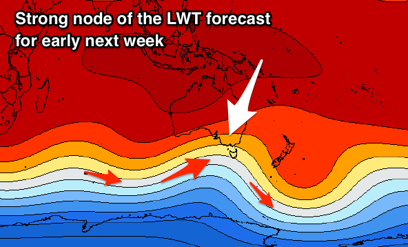
Moving into next week, and as touched on last update, a node of the Long Wave Trough is due to strengthen across the south-east of the country through the weekend. This will steer and strengthen a series of cold fronts from the Southern Ocean up and into us, the first developing around the Heard Island region tomorrow evening and projecting a fetch of W/SW gales through our western swell window before weakening and moving through Sunday evening.
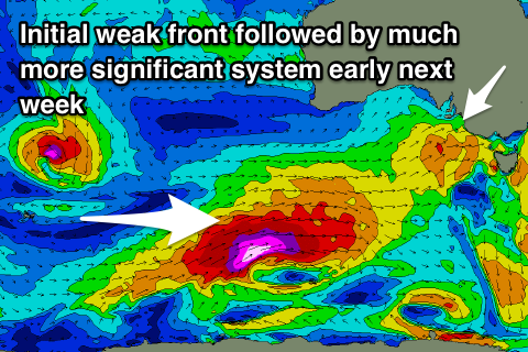 An inconsistent though fun sized W/SW groundswell should be seen from this front, arriving later Monday and peaking early Tuesday. The Mid Coast should see inconsistent 1-2ft sets late in the day Monday but more so Tuesday morning, with 3ft sets off Middleton Tuesday morning along with an average and gusty S/SW breeze associated with a much stronger storm outlined below.
This more significant storm will strengthen south of WA and project an elongated fetch of severe-gale to storm-force W/SW winds through our south-western swell window, before projecting up towards us Monday and Tuesday.
A large long-period SW groundswell will be generated, kicking Tuesday afternoon and peaking overnight. Early estimates have it coming in around 6ft+ across Middleton and 2ft+ on the Mid Coast with those onshore winds, easing Wednesday with more variable breezes, but more on this and the expected size Friday.