Fun swell but average winds to end the week, slowly improving on the weekend

South Australian Forecast by Craig Brokensha (issued Wednesday 20th February)
Best Days: Keen surfers South Coast Saturday morning, swell magnets Sunday morning, beginners on the Mid Coast tomorrow afternoon and Friday
Recap
A good pulse of swell yesterday with workable 1-2ft waves on the Mid Coast and solid bumpy waves on the South Coast for keen surfers. This morning the South Coast has cleaned right up with our expected morning W/NW'ly coming through and fun easing sets from a smaller 3ft. The Mid was also clean but tiny.
Today’s Forecaster Notes are brought to you by Rip Curl
This week and weekend (Feb 21 - 24)
We'll see the surf continuing to drop this afternoon as winds tend back onshore across the South Coast and the end of the week is looking generally poor with onshore SE tending S/SE winds tomorrow, lighter out of the E/SE or possibly E Friday but with not enough time to clean up the swell.
 A fun new mid-period SW swell should fill in tomorrow afternoon though, easing slowly through Friday mixed in with a very inconsistent long-period signal.
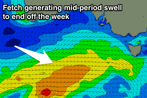
The mid-period swell is being generated by an elongated frontal system currently south-west of us, producing a fetch of strong W/SW winds.
Our models are incorrectly combining the new swell with the existing easing energy later tomorrow and Friday morning, over-forecasting the expected sized.
What we can expect is Middleton to kick back to 3ft+ later tomorrow and ease from a similar size Friday, with the Mid Coast coming in around 1ft, ideal for beginners.
The swell will continue to ease over the weekend and unfortunately winds will take their time in swinging offshore.
Saturday should see E-E/NE winds and peaky easing waves from 2ft+ off Middleton, more NE Sunday morning but with no decent size at all. Middleton will likely be tiny, with small fading 2ft+ sets at Waits and Parsons.
As touched on last update, there's nothing of significance due into next week at this stage owing to a large blocking high and lack of distant swell generating storms. More on this and any changes to the outlook on Friday.