Building and strengthening swells, very active from the weekend

South Australian Forecast by Craig Brokensha (issued Monday 15th October)
Best Days: Later tomorrow for keen surfers South Coast, keen surfers South Coast Wednesday morning, both coasts Wednesday (Mid Coast afternoon), early Friday South Coast, Saturday and Sunday South Coast
Recap
Small clean waves across the South Coast swell magnets on Saturday morning, tiny to flat on Sunday while the Mid Coast was clean but flat all weekend.
Today is similar with no surf on either coast.
Today’s Forecaster Notes are brought to you by Rip Curl
This week and weekend (Oct 16 – 21)
Currently a small mid-latitude low has formed in the Bight and we'll see this low moving slowly east through this evening and tomorrow, aiming a fetch of strong W/SW-SW winds through the Mid Coast's and then South Coast's swell window.
The low looks a touch weaker than forecast last Friday but longer lived and as a result the Mid Coast looks to build from a small 1-2ft tomorrow morning to 2-3ft into the afternoon with strong W/NW winds.
The South Coast is due to be tiny to flat tomorrow morning, with a mix of new small W/SW groundswell and W/SW swell from the low building into the afternoon.
Size wise we're only likely to see 2ft sets developing across Middleton later in the day as winds hold out of the W/NW-W.
Come Wednesday the low is expected to still be lingering but weakening with winds remaining from the W/SW tending SW. There's a good chance for an early W/NW'ly around Victor and we'll see a mix of swells coming in 2ft off Middleton and easing from 2-3ft on the Mid Coast.
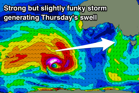 Later in the day and more so Thursday our stronger W/SW groundswell is due to fill in, generated by a much more significant storm that developed south-west of Western Australia, with a pre-frontal fetch of severe-gale W/NW winds followed by a burst of tight storm-force W/SW winds and trailing strong to gale-force W/SW winds.
This has generated a fun pulse of W/SW groundswell that is a touch tricky to forecast owing to the funky structure of the storm but we should see it building later Wednesday and peaking Thursday morning to 3ft off Middleton (bigger sets towards Goolwa), and 2ft on the Mid Coast.
Winds through the morning look a little average and onshore from the W/SW (possibly W/NW early around Victor – we'll review this Wednesday), with variable winds due into the afternoon creating improving conditions.
Friday morning looks super fun as the W/SW groundswell eases though a strong mid-latitude front racing in from the west will bring strong N'ly winds ahead of a W/SW change, kicking up some new windswell on the Mid Coast.
This front will be the first in a series of continued activity all through next week and likely into the following week owing to a strong and stalling node of the Long Wave Trough across the Bight.
Back to back pulses of W/SW groundswell are due, with what looks to be generally favourable winds. We'll have a closer look at this on Wednesday though.