Great weekend, large surf to develop again next week

South Australian Forecast by Craig Brokensha (issued Friday 20th July)
Best Days: South Coast all weekend, Mid Coast tomorrow, South Coast Tuesday, Wednesday and Thursday, Mid Coast Wednesday and Thursday morning
Recap
An early window of N'ly winds and workable conditions across the Mid Coast yesterday with surf in the 3ft range, average and messier today with a slight drop in size.
The South Coast saw large though inconsistent and pulsey surf across the region, best in protected spots with winds from the western quadrant. The size looked a little under expectations, with the west in the swell direction limiting any huge surf across the South Coast.
This morning the swell was a touch smaller though still large and good in protected spots again with a localised W/NW breeze.
Later today we should see a new large pulse of SW swell across the state as winds shift W/SW, discussed in more detail below.
Today’s Forecaster Notes are brought to you by Rip Curl
This weekend and next week (Jul 21 - 27)
Want to receive an email when these Forecaster Notes are updated? Then log in here and update your preferences.
Yesterday's large reinforcing pulse of long-period W/SW groundswell was generated by a severe low forming under WA, and tracking east and then east-southeast towards Tassie.
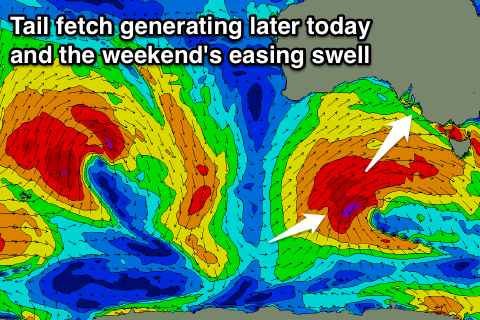 On the backside of this low though, we've seen a persistent fetch of W/SW gales generated in our swell window, with an even better tail fetch of severe-gale W/SW tending SW winds projecting nicely towards us through yesterday.
This system is now weakening while pushing up towards Bass Strait, but we should see a new large long-period SW groundswell filling in later today across the South Coast, easing from a more S/SW direction over the weekend.
Conditions will be excellent for the South Coast as an approaching front swings N/NW tomorrow, persisting all day with easing sets from the 6ft range off Middleton, down to 4ft into the afternoon and more rapidly from 3ft Sunday morning. Fresher N-N/NW winds will create ruler edge perfection Sunday, best at magnets as the swell fades.
The Mid Coast should drop back from the 2ft range tomorrow and with an early N/NE breeze, fresher Sunday with tiny 1ft+ leftovers.
Later in the day on the Mid Coast a new W/SW swell may be seen, but Monday is a better chance for this.
The swell will be generated by a pre-frontal fetch of weakening W/NW gales ahead of a very significant polar frontal progression, but more on this below.
Monday's swell looks to come in at small 1-2ft on the favourable parts of the tide, while not really affecting the South Coast with small infrequent 1-2ft waves due off Middleton.
N/NW winds will favour the South Coast again, possibly giving into a late W/NW change.
Of greater importance is a large long-period W/SW groundswell due to build through Tuesday and peak into the evening, with a secondary pulse Wednesday.
 One of the strongest polar frontal progressions of the year will developing south-west of WA, under the influence of a strong protruding node of the Long Wave Trough in the south-east Indian Ocean.
The winter calibre frontal progression will occur in our medium-far western swell window, producing the largest swell of the season for Indo, coming in strong across our region mid-week.
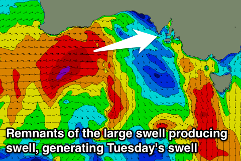
The bulk of the long-period energy is due Wednesday, but remnants from the front proper look to push across us through Tuesday, aiming W/SW gales through the Bight and across us into Tuesday.
This will generate moderate to large levels of mid-period W/SW swell for Tuesday, coming in at a stormy though easing 3-4ft on the Mid Coast with strong and easing W/NW winds.
The fetch generating this swell looks too north for the South Coast and blocked up Kangaroo Island, and the models are incorrectly combining swells again, with weaker smaller 3ft sets due off Middleton in the morning, building to 4ft later in the day.
The groundswell is expected to provide more size with sets to 4-5ft+ off Middleton and strong 3ft to occasionally 4ft on the Mid Coast. Winds are tricky at this stage but look favourable for the South Coast Wednesday and Thursday, with windows for the Mid Coast, but more on this Monday. Have a great weekend!