Wind, wind, wind: it's gonna get windy

South Australian Forecast by Ben Matson (issued Monday 2nd July)
Best Days: Mid Coast: stormy conditions from Wed thru' Sun. Biggest Fri/Sat with waves on metro beaches. South Coast: clean until the weekend though only small until Fri. Wed/Thurs should have pockets of workable conditions with small/mod but very inconsistent swells.
Recap: Fun waves at Victor over the weekend with an early window of W’ly winds Saturday, tending SW into the afternoon but then veering N’ly for Sunday and Monday. Surf size held out around 2-3ft all weekend but has eased a little today. The Mid saw small lumpy surf all weekend with average conditions. Size has also eased here today.
Today’s Forecaster Notes are brought to you by Rip Curl
This week and weekend (Jul 3 - 8)
Want to receive an email when these Forecaster Notes are updated? Then log in here and update your preferences.
Note: Today’s Forecaster Notes will be brief, as Craig is away on annual leave. Also, these Forecaster Notes will be updated Tuesdays, Thursdays and Saturdays for the next few weeks.
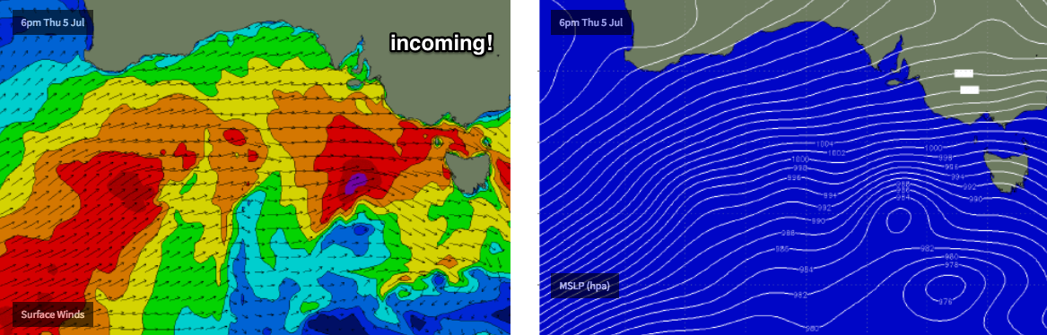
We’ve got a classic winter frontal progression bearing down on the southern states. It’s just started to smash WA, and will influence our region for the next week or so.
These fronts are being steered by an amplifying Long Wave Trough near WA longitudes, of which South Australia will reside on its eastern flank until the end of the week.
It’s a great synoptic pattern for swell on the Mid Coast though we’ve obviously got a lot of onshore wind to deal with. The broader picture looks gusty N/NW Tuesday, NW Wednesday, NW tending W/NW Thursday, W’ly tending W/NW Friday then W/SW tending SW through Saturday, finally S/SW into Sunday.
As such conditions won’t be great, and actual wave size will be dictated by the strength of the wind, and the percentage of west in its direction. Aside from a low point Tuesday, we’ll see building swells from Wednesday onwards that should maintain a baseline of 2-3ft groundswell right through until Sunday, but with stormy episodes contributing another couple of feet of windswell later Thursday, Friday and Saturday (and offering fun waves along the metro beaches at times).
Conditions will remain clean though blustery down south all week. However, the storm track isn’t great for Victor at first: the LWT is steering vigorous fronts up into WA, before directing them through the Bight, which is the northern periphery of its acute western swell window.
Tuesday’s low point will rise slightly into Wednesday but even Thursday won’t see a lot of size - maybe some wind affected 2-3ft sets between Middleton and Day Street if we’re lucky.
Friday is when we’ll see a more prominent increase in size (with W’ly gales accompanying) as the LWT starts to move into our swell window, ahead of large onshore surf for Saturday than should push 6ft+ at exposed spots. However there’ll still be a decent amount of west in the swell direction so sheltered spots around Victor will remain pretty small.
Strong swells and easing S/SW winds are then expected Sunday.
Next week (July 9 onwards)
Main points for next week: strong swells for the most part thanks to a series of fronts cycling through the eastern periphery of our swell window (on the backside of the LWT), though down in size from the weekend and easing from Wednesday onwards. Winds will rapidly ease to become light and variable.