Strong W/SW groundswell for Friday, clean and easing over the weekend

South Australian Forecast by Craig Brokensha (issued Wednesday 28th March)
Best Days: Mid Coast keen surfers Friday, early protected spots down South Friday, both coasts Saturday morning, South Coast Sunday morning, Mid Coast for tiny peelers Tuesday
Recap
Tiny leftover surf to 1ft on the Mid Coast yesterday, with a similar sized though new W/SW windswell today.
The South Coast pumped all day yesterday with strong sets easing from 3-4ft under a persistent offshore wind. This morning there was no swell left at all with leftover bumpy 1-2ft waves off Middleton.
Today’s Forecaster Notes are brought to you by Rip Curl
This week and weekend (Mar 29 – Apr 1)
Today's tiny increase in W/SW windswell is the precursor to a much stronger W/SW groundswell due later tomorrow and Friday.
This groundswell has and is still being generated by a strong frontal progression that developed east of Heard Island and pushed north-east under WA through this week.
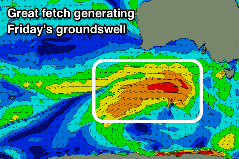 Currently we're seeing a broad fetch of strong to gale-force W/SW winds projected through our western and south-western swell windows (generating a strong W/SW groundswell), with the storm due to weaken but stall south-southwest of us tomorrow.
We'll see a polar low form, generating an additional fetch of strong to gale-force W/SW winds in our southern swell window tomorrow and Friday morning, producing a reinforcing S/SW groundswell for Saturday afternoon and Sunday morning.
But coming back to tomorrow and the Mid Coast is expected to be tiny and around 1ft through the morning, kicking to 1-2ft later in the day with a peak Friday to 2ft to occasionally 3ft on the favourable parts of the tide.
The South Coast will remain small to tiny tomorrow morning, building later to 2-3ft off Middleton and then peaking Friday to 3-5ft.
Winds tomorrow should be light to moderate from the W/NW early, shifting W/SW through the day, with Friday seeing persistent moderate to fresh W/SW tending SW winds (likely W/NW early around Victor).
The weekend is looking much cleaner with the W/SW groundswell due to ease from a more SW direction, slowed into the afternoon with the arrival of the reinforcing S/SW groundswell.
The South Coast should provide sets to 4ft off Middleton, easing a touch through the day, down steadily from 3ft on Sunday morning.
The Mid Coast is due to ease back from 2ft on the sets Saturday, tiny Sunday.
Winds, as touched on above are looking great with variable tending N/NE breezes down South Saturday, more NE on the Mid Coast before weak sea breezes kick in.
Sunday will see similar variable winds but from the NW during the morning, giving into a SW change through the day, so don't leave it too long.
This change will be linked to a front racing under the Bight and south of us, with a burst of strong to gale-force W/SW winds expected to generate a new SW groundswell for Monday.
Unfortunately a strong high moving in from the west will bring S/SW winds Monday, tending more S/SE on Tuesday with a secondary pulse of weaker swell off another weak front.
These fronts will be too south to generate any decent size on the Mid Coast with 1ft surf due for the most part, possibly pulsing to 1-1.5ft through Monday and Tuesday with the favourable parts of the tide.
Longer term we may see a new S/SW groundswell Thursday with improving winds, but more on this Friday.