Large groundswell for tomorrow, cleanest on the Mid Coast, better down South late week

South Australian Forecast by Craig Brokensha (issued Monday 19th March)
Best Days: Mid Coast tomorrow and Wednesday, South Coast Thursday morning, Friday and Saturday morning
Recap
Great waves most of the day across the South Coast Saturday with a good easing S/SW groundswell from the 3ft range off Middleton. The Mid Coast was tiny and choppy.
Come Sunday a stormy windswell was whipped up across the Mid Coast, coming in at 3-4ft, with bumpy building surf down South.
This morning the W/SW swell has held in around 3ft across the South Coast with bumpy conditions while the Mid Coast dropped back to a bumpy 2-3ft.
A stronger and larger SW groundswell should start kicking later today, produced by a vigorous mid-latitude front pushing under the Bight over the weekend.
We should see Middleton kicking later to 4-6ft as winds shift W/SW while the Mid Coast persists at 2-3ft.
Today’s Forecaster Notes are brought to you by Rip Curl
This week and weekend (Mar 20 - 25)
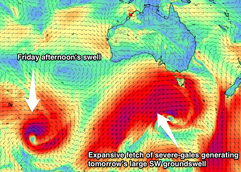
Later today's strong pulse of SW groundswell will be followed up by a large increase in SW groundswell tomorrow.
Following right behind the mid-latitude storm linked to later today's swell is an elongated fetch of gale to severe-gale W/SW winds, extending from south-southwest of WA on the polar shelf, all the way up to Victoria.
This fetch is working on top an already active sea state and projecting slightly towards us the south-east of the country resulting in a large SW groundswell tomorrow.
 We should see Middleton building to 6-8ft through the day, with the Mid Coast coming in at 3ft on the favourable parts of the tide.
As talked about last week, a strong high will quickly slide in from the west this evening, swinging winds around to a gusty SE-S/SE tomorrow. This will create poor conditions down South but great conditions on the Mid Coast.
Into Wednesday we'll see the swell easing across both coasts, likely from 2ft on the Mid Coast and the 6ft range down South as winds swing more E/SE. There's an outside chance will tend more E/NE down South later morning, but the surf will still be all over the place.
Come Thursday though we'll see much better though fresh NE winds across the South Coast as the swell continues to ease from 3ft to occasionally 4ft of Middleton, back to 2-3ft into the afternoon. The Mid is likely to back off to a tiny 1ft.
Friday morning will be cleaner again, and with a new S/SW groundswell due to fill in through the afternoon.
This is being generated by a tight and intense low that's currently east of Heard Island, generating a fetch of severe-gale to storm-force W'ly winds. The swell will be good but inconsistent, reaching an inconsistent 3ft off Middleton into Friday afternoon, tiny to flat on the Mid Coast. A N/NE breeze should last until mid-afternoon before sea breezes try and creep in.
Into the weekend we'll see the S/SW groundswell easing under a morning offshore, with strengthening onshore winds and a building S/SW windswell later Sunday as a small intense mid-latitude low pushes into us. More on this Wednesday.
Comments
Nice waves via our new Trigs surfcam.. high tide and low tide.
Ah! Triggs
What a cute little wave , memories of fairly uncrowded days in the 70’s