Small window of clean waves on the weekend, large swells early-mid next week

South Australian Forecast by Craig Brokensha (issued Friday 16th March)
Best Days: South Coast early Saturday, South Coast Monday, Mid Coast later Tuesday and Wednesday
Recap
Good fun waves across the South Coast yesterday morning with light winds from the north-eastern quadrant and solid sets holding 3-4ft off Middleton. This morning we fell in between swells but conditions are great with straight offshore winds, and some new S/SW groundswell has started to show with good sets from Goolwa to Victor. We'll see conditions remain good all day as the swell peaks this afternoon.
The Mid Coast has been tiny to flat the last couple of days.
Today’s Forecaster Notes are brought to you by Rip Curl
This weekend and next week (Mar 17 - 23)
Today's pulse of S/SW groundswell is due to peak this afternoon and then ease back through tomorrow.
We should see see inconsistent sets to 3ft off Middleton early, easing through the day under an early fresh N/NW wind, shifting W/NW-W/SW through the late morning with a vigorous approaching front. So go the early.
This front will be the first in a series of very strong storms, firing up under the influence of a strong node of the Long Wave Trough moving across us early next week.
We'll see this front project a fetch of strong to gale-force W/SW winds through the Bight on Saturday, generating a moderate sized increase in windy W/SW swell for Sunday.
 The Mid Coast should see stormy surf to 3ft in the morning with gusty but easing SW winds.
The swell will be super west for the South Coast and build to 3ft+ off Middleton through the afternoon with strong W'ly tending W/SW winds.
A larger SW groundswell is the due to build Monday, produced by a secondary better aligned fetch of severe-gale W/SW winds racing in south of the Bight Sunday, on top an active sea state.
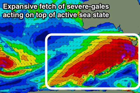
Extending out behind this mid-latitude fetch will be an expansive fetch of severe-gale SW winds nearly the size of Australia stretching from south-southwest of WA all the way to Victoria.
This and an embedded fetch of storm-force winds projecting towards the south-east of the country on top of the very large active sea state will result in a very large swell for Tuesday afternoon/evening and Wednesday morning.
The only issue are the local winds, with a strong high due to move in quickly on Monday evening, bringing poor S/SW tending S/SE winds for the South Coast Tuesday, SE-E/SE winds Wednesday.
Coming back to the swells though and we should see Monday coming in at 2-3ft on the Mid Coast, with the South Coast building from 3ft or so during the morning, upwards towards 4-6ft later in the day with W/NW winds until late afternoon.
Come Tuesday and Wednesday when winds swing onshore, the Mid Coast should see good surf to 3ft on the favourable parts of the tide, with the South Coast large and messy to 8ft on the sets later Tuesday, easing from 6-8ft Monday.
We'll have a closer look at this Monday though, have a great weekend!