OK waves tomorrow, excellent Friday with large surf next week

South Australian Forecast by Craig Brokensha (issued Wednesday 14th March)
Best Days: South Coast keen surfers tomorrow morning, Friday South Coast, protected spots South Coast Saturday morning
Recap
A large S/SW groundswell with not the best, but workable winds across the South Coast yesterday, tiny and around 1ft on the Mid Coast.
This morning the swell has eased a little though was still solid and conditions a touch better again with a E'ly breeze.
Today’s Forecaster Notes are brought to you by Rip Curl
This week and weekend (Mar 15 - 18)
The last two days of strong swell were generated by back to back polar frontal systems pushing towards Tasmania, and we're due to see another slightly smaller reinforcing S/SW swell for tomorrow morning.
This has been generated by a fetch of W'ly gales swinging in from the south-east Indian Ocean, pushing east and under Tassie.
Middleton should continue to see 3ft to occasionally 4ft sets tomorrow morning, dropping back through the day. The Mid Coast will remain tiny and around 0.5-1ft. Winds are due to be similar to this morning with a light E-E/NE breeze creating OK conditions.
Moving into Friday and winds are looking much better along with a new strong S/SW groundswell.
 Last night a vigorous polar low formed south-west of Tasmania, with a fetch of severe-gale W/SW winds already being generated in our southern swell window. There are a couple of 50kt barbs in the mix as well, and we'll see this low project similar strength severe-gale to storm-force winds north-east towards Victoria today, producing a moderate to large long-period S/SW groundswell.
We should see this swell peaking through the day to a strong 4-5ft across Middleton, tiny on the Mid Coast and with excellent N/NE tending NW winds.
The swell is due to ease later in the day, down from the 3ft range Saturday with varying winds as a touch moves through. Early NW winds are due to swing W'ly but may tend back more W/NW into the afternoon, but check back here Friday for more on this.
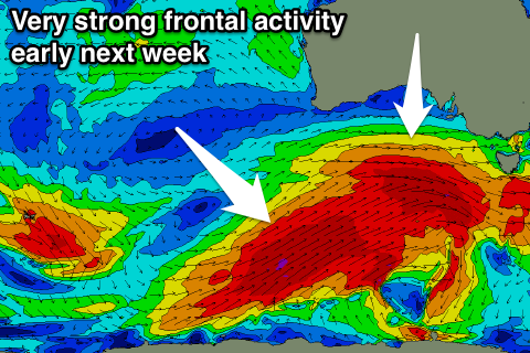
From Sunday we'll see the first of a series of vigorous fronts pushing through, owing to a new strong node of the Long Wave Trough moving in from the west.
This will project strong and broad polar fronts through our swell window, resulting in large levels of SW groundswell early next week.
Initially Sunday's change will kick up a stormy increase in swell on the Mid Coast, but we'll look at the specifics on Friday.