Fun waves to end the week on the South Coast

South Australian Forecast by Craig Brokensha (issued Wednesday 7th March)
Best Days: Thursday and Friday mornings down South
Recap
Poor sloppy onshore windswell across the South Coast yesterday with plenty of size, a bit cleaner but still average this morning. The Mid Coast has hovered around 0.5ft.
Today’s Forecaster Notes are brought to you by Rip Curl
This week and weekend (Mar 8 - 11)
The end of the week is looking fun across exposed breaks down South with a new S/SW groundswell for tomorrow along with improving winds.
 This has been generated by a strong polar low pushing through our southern swell window the last couple of days with straight 2-3ft sets due off Middleton tomorrow with a touch more size at Waits and Parsons. The Mid Coast will be flat.
This swell will ease back from a small 2ft off Middleton on Friday, tiny into Saturday.
Conditions each morning will be good with a NE breeze due to develop through tomorrow morning, with some peakiness to the surf with leftover S/SE windswell. Friday morning should see straighter NE-N/NE winds ahead of sea breezes, similar Saturday.
The surf will bottom out Sunday as an onshore change moves through.
Next week onwards (Mar 12 onwards)
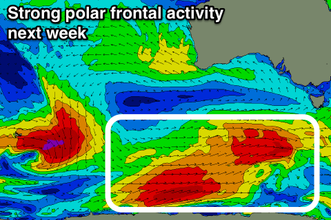
As touched on last update, a node of the Long Wave Trough will strengthen and stall across Victoria next week, resulting in back to back frontal systems firing up in the Southern Ocean towards Tasmania.
An initial system developing under WA Saturday afternoon and projecting towards Tassie should produce a moderate sized S/SW groundswell for later Monday but more so Tuesday, with a secondary pulse for Wednesday afternoon/Thursday.
Unfortunately winds look poor for the South Coast with S/SE winds. The Mid Coast will be cleaner but the swell a bit too south to offer anything over 1-1.5ft. More on this Friday.