Good waves tomorrow morning then average until Tuesday next week

South Australian Forecast by Craig Brokensha (issued Friday 16th February)
Best Days: South Coast Saturday morning, South Coast Tuesday morning and magnets for keen surfers Wednesday morning, Mid Coast Thursday afternoon
Recap
A good reinforcing SW swell for both coasts yesterday with 2ft sets across the Mid Coast, most consistent and best into the afternoon, while the South Coast was great yesterday morning with 3-4ft sets off Middleton and clean conditions.
This morning the swell was still up down South but with a light onshore wind, while the Mid Coast was full and back to 1-1.5ft with early variable winds.
Today’s Forecaster Notes are brought to you by Rip Curl
This weekend and next week (Feb 17 - 23)
The swell seen the last couple of days was generated by back to back mid-latitude fronts, clearing to the south-east yesterday.
Overnight though we've seen a strong polar low form to our south, with a fetch of strong to gale-force W/SW winds in our southern swell window, while stronger storm-force winds at the lows core were probably generated a little too east and out of our swell window.
Still we should see moderate amounts of S/SW swell through tomorrow morning, coming in at 3ft to occasionally 4ft across Middleton, easing slowly through the day, down from 2-3ft on Sunday.
 This swell isn't ideal at all for the Mid with it being too south, so we'll see the size continuing to drop from 0.5-1ft max tomorrow, near flat Sunday.
Winds tomorrow morning will be favourable and variable tending light offshore from the NE-N/NE before sea breezes start developing around midday. Sunday then looks average as a trough moves in from the west bringing S/SE-SE winds.
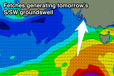
This trough will create poor conditions through early next week, spoiling a new S/SW groundswell that's currently being generated just west of the strong polar low. A polar front is projecting a fetch of strong to gale-force SW winds up towards Victorian, with this swell due to come in around 3ft+ across Middleton Monday.
Fresh and gusty SE tending S/SE winds will create poor conditions though with no size expected on the Mid.
Tuesday will be cleaner but peaky with a morning E/NE wind and easing S/SW swell from 2ft+ off Middleton.
Wednesday morning looks clean again but with no new swell and small to tiny waves.
Into Thursday and Friday some small new W/SW swell is due, favouring the Mid Coast as winds go S'ly in the wake of a trough.
This will be generated by a mid-latitude storm drifting in from the south-east Indian ocean, initially generating an unfavourable fetch of S/SW gales aimed more towards WA before the remnants of the storm re-intensify south of WA early next week.
If we're lucky we could see 1-2ft of W/SW swell for the Mid Coast Thursday afternoon, but check back Monday for more on this. Have a great weekend!