Poor S/SE windswell, with a window of clean waves on the weekend

South Australian Forecast by Craig Brokensha (issued Wednesday 15th November)
Best Days: No great days, but Sunday morning at South Coast swell magnets is the pick
Recap
Fun waves across the Mid Coast yesterday with a pulsey W/SW swell to 1-1.5ft and good winds up until late afternoon when a weak W/SW change moved through. The South Coast was fun at exposed breaks but only small.
This morning the W/SW swell was hanging in around a similar size on the Mid with early light W'ly winds which have remained variable into the middle of the day.
The South Coast was clean early though a gusty S'ly change has since moved through as a trough pushes in from the west.
This week and weekend (Nov 16 - 19)
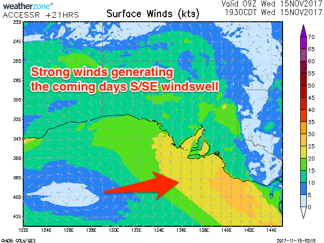
The coming forecast period isn't too flash at all, with today's surface trough projecting a fetch of strong S/SE winds through the South Coast's swell window today and tomorrow, persisting right until early Friday morning before the trough weakens.
What we'll see is moderate amounts of S/SE windswell across the South Coast with 3-4ft sets across most locations though with gusty S/SE-S winds. The Mid Coast will be cleaner but fading from 0.5-1ft.
 The windswell looks to now hold into Friday morning at 3-4ft as winds swing more S/SW, keeping conditions well below par.
An easing trend will be seen into the afternoon, while come Saturday we'll see only small levels of leftover swell as winds linger from the S'th.
Into the afternoon our new SW groundswell is still on the cards, generated by a polar low in the Heard Island region early this week.
No major size is due from this low, with Middleton expected to build to 2ft+ later in the day, easing back from an inconsistent 2ft Sunday morning. The Mid Coast won't see any size at all from this swell.
Wind should swing back to the NE for Sunday morning creating favourable conditions at selected locations but get in through the morning as the swell will become tiny into the afternoon, similar Monday.
Longer term we should see a fun W/SW groundswell moving into the state on Wednesday, generated by a slow moving polar low south-west of WA, but more on this Friday.