Small average fading surf, very large early next week

South Australian Forecast by Craig Brokensha (issued Wednesday 25th October)
Best Days: South Coast Sunday, Mid Coast mid-late morning Sunday, protected spots South Coast Monday, metro beaches north of the Mid, both coasts Tuesday
Recap
Small waves yesterday down South with variable winds for most of the day, creating OK conditions for keen surfers at swell magnets. This morning was similar in size but bumpier with an E'ly wind.
The Mid Coast has been tiny to flat the last couple of days with nothing of note.
This week and next week (Oct 26 – Nov 3)
The coming days will remain void of any decent swell activity with today's small bump in SW groundswell due to fade through tomorrow from a small 1-2ft across Middleton (mixed in with a weak windswell) along with persistent onshore S/SW winds.
Friday will become tiny to flat as an approaching front brings freshening N/NE tending NW winds ahead of a late W/SW change.
The surf will remain tiny to flat down South into Saturday, while the Mid Coast should see a small spike in W/SW swell through the day, produced by a weakening front pushing towards and under WA today and tomorrow.
 We should see a good increase in W/SW swell through Saturday afternoon to 1-2ft, with the morning revealing weaker 1-1.5ft sets. Conditions will be average in any case with a moderate to fresh W/NW breeze.
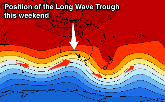
Of much greater importance is the following storm activity, owing to a strengthening node of the Long Wave Trough moving in from the west.
The first significant front should move in on top of the active sea state generated by the weak front before it, producing a good fetch of gale to severe-gale W/SW winds up into the Bight through Friday before dipping south-east while approaching us.
A moderate sized W/SW groundswell is due for Sunday arriving mid-morning and offering good 2-3ft sets on the Mid Coast, while Middleton should see good sets to 3ft all day.
Winds will be great Sunday morning for the South Coast with a fresh N/NW offshore breeze, strengthening and tending more W/NW into the afternoon as a very intense storm approaches from the west, discussed below.
Behind the front generating Sunday's W/SW swell, a very intense and deep low pressure system is forecast to form south-west of WA, bottoming out in central pressure at 954 hPa.
As this low deepens a very impressive fetch of storm-force W/SW winds will be generated in our western swell window from Friday evening, pushing slowly east through the Bight (on top an active sea state from the systems before) while maintaining its strength.
The prolonged fetch of storm-force winds is quite amazing and with we'll see an XXL swell generated for our West Coast.
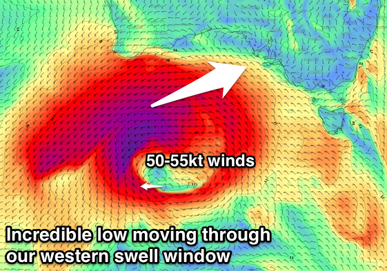 With core wind speeds reaching 50-55kt+ peak periods are also due to reach 20s, and we should see the groundswell arriving early Monday morning, peaking in the large range all day.
The Mid Coast is set to see 4-5ft of W/SW groundswell, mixed in with some local windswell with fresh to strong but easing W/SW winds, while Middleton is expected to reach 6-8ft+ through the morning with larger surf at exposed breaks.
Winds won't be ideal as touched on above, but there is a chance for an early W/NW breeze around Victor (we'll review this Friday).
Tuesday looks much cleaner with lighter W/NW breezes across both coasts and a drop in W/SW groundswell, though we may see a new reinforcing SW groundswell mid-week from another deep powerful low. More on this Friday.