Fun South Coast days, larger over the weekend but winds may be an issue

South Australian Forecast by Craig Brokensha (issued Monday 21st August)
Best Days: South Coast tomorrow and Wednesday morning, protected spots Thursday and Friday mornings
Recap
Good fun waves across the Mid Coast Saturday in the 2ft range as winds swung offshore, while the swell was back to a tiny 0.5ft Sunday.
The South Coast improved with lighter onshore winds and a good amount of swell to 3-4ft off Middleton. Winds tended more variable through the day allowing conditions to improve further.
Sunday was much cleaner as strengthen N/NE winds straightened out the smaller easing swell.
An intense mid-latitude low that was forecast to generate a solid increase in W'ly swell across the Mid Coast today if it tracked south enough ended up staying weak and tracking north, resulting in only tiny waves across the Mid Coast, while the South Coast remained small and bumpy.
This week and weekend (Aug 22 - 27)
We've got some fun SW groundswell due over the coming days, with the best being for Wednesday morning.
Tomorrow morning, an inconsistent SW groundswell should see 2-3ft sets off Middleton, while the Mid Coast will remain tiny and in the 0.5-1ft range.
Later in the afternoon a mix of new SW groundswell and mid-period SW swell are due to start building, generated by essentially the same storm.
The inconsistent long-period SW energy was generated in the Heard Island region, while the remnants of the storm, projected closer towards us while weakening, generating a closer-range SW swell.
Both swells are due to fill in around the same time, building later tomorrow ahead of a peak Wednesday morning to 3ft to occasionally 4ft off Middleton and 1ft on the Mid Coast.
 A persistent W/NW-NW breeze will create good conditions tomorrow, while NW breezes will persist Wednesday morning ahead of a SW change through the afternoon.
The swell should ease back slowly through Thursday and Friday with a possible early W/NW'ly around Victor Thursday morning, NW Friday. A weak front projecting towards us from the Indian Ocean today and tomorrow is due to produce a small W/SW swell for the Mid Coast Friday, but only to 1ft+ or so, and with increasing onshore winds.
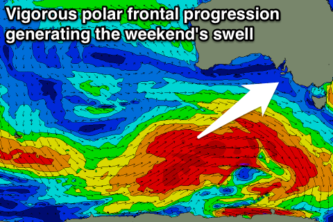
Of greater importance is a much stronger polar frontal progression firing up into the end of the week (touched on in last week's notes), generating larger and better aimed swell into the weekend.
A pre-frontal fetch of gale to severe-gale W/NW winds will move in under the Bight through our south-western swell window Wednesday and Thursday morning, followed by a broader and better aligned polar fetch of post-frontal W/SW winds.
At this stage no size is due before dark Friday but we'll see a SW groundswell Saturday morning, with a possible late pulse of stronger SW groundswell energy late in the day, peaking Sunday morning.
Middleton should see 3-4ft waves Saturday morning, pulsing to the 5ft range later and easing from a similar size Sunday. The swell won't be great for the Mid but 1-2ft sets are likely on the favourable parts of the tide.
Winds are still a bit up in the air, so check back here Wednesday for an update on this and the expected size.
Comments
The Bay! Theres a couple reeling through with just a handful of crew in the water.
Absence doesn't make the heart grow fonder. But, that's a decent size for the inside section (see old mate, third pic). Couple of very fat peaks off the point too.