Lots of swell this week with varying winds

South Australian Forecast by Craig Brokensha (issued Monday 31st July)
Best Days: Both coasts tomorrow, Mid Coast Wednesday afternoon and Thursday morning, South Coast Friday morning, Saturday and Sunday protected spots down South, next Monday down South
Recap
Choppy 1-1.5ft waves on Saturday across the Mid Coast, while Sunday a strong new W/SW groundswell filled in, providing solid 3-4ft waves with a moderate NW breeze.
The South Coast was tiny and bumpy on Saturday with strong offshore winds, while the swell kicked into Sunday with good winds for protected spots.
This morning both coasts were offering good waves with easing 2-3ft sets on the Mid Coast with lighter winds and clean surf in the 4ft range down South.
This week and weekend (Aug 1 - 6)
Today's swell will continue to ease through tomorrow, with light to moderate N/NE winds all day down South and early NE tending N/NE winds on the Mid. Easing sets from 1-2ft are due on the Mid Coast with easing 2-3ft waves down South across Middleton.
The swell is due to bottom out Wednesday morning ahead of some new W/SW and SW groundswell into the afternoon.
These swells are being generated by a splitting polar frontal systems that's currently south-west of WA.
A good fetch of weakening W/SW winds are being aimed through the Mid Coast's swell window, with a polar fetch of severe-gale to storm-force W'ly winds.
We'll see a W/SW and SW groundswell arrive at similar times Wednesday, with the west swell building on the Mid Coast as the SW groundswell builds across the South Coast.
The Mid Coast should kick to 1-2ft through the afternoon, though the dropping tide isn't ideal, while Middleton is expected to reach 3ft. Winds will vary but favour the Mid Coast in general as two separate mid-latitude lows sit west and east of us. A fresh NE tending E/NE breeze is most likely, with winds swinging onshore S/SE to S/SW on Thursday.
This will be along with a new pulse of SW groundswell, generated by an elongated pre-frontal fetch of NW gales through our swell window over the coming days.
 Middleton should hang in the 3ft range through the afternoon and Friday morning before easing slowly. The Mid Coast looks to also hang around 1-2ft Thursday before fading Friday.
An about face in winds will also be seen Friday as a strong front approaching from the west generates strengthening N/NW tending W/NW winds.
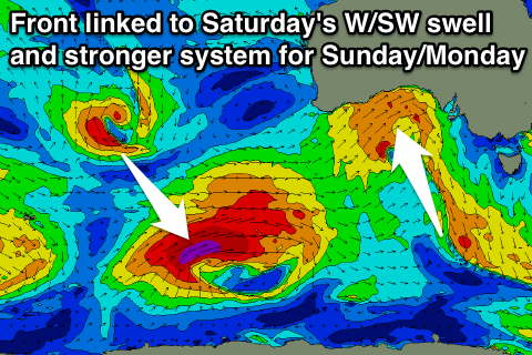
This front will bring with it a moderate sized W/SW swell for Saturday with a broad fetch of strong to gale-force W/SW winds being projected towards and then under WA, through the Bight and across us Friday evening.
The Mid should see messy 3ft waves with a moderate to fresh W/NW breeze, while the South Coast will be cleaner and offer solid sets to 3-5ft off Middleton.
An even stronger polar low projecting towards us through the end of this week and during the weekend is expected to produced a larger SW groundswell for Sunday afternoon and Monday morning with what looks to be NW winds, but more on this Wednesday.