Extended run of great waves for the South Oz Mid Coast

South Australian Surf Forecast by Ben Matson (issued Friday 2nd June)
Best Days: Great waves almost every day on the Mid Coast. Biggest Monday. Plenty of great surf at Victor too.
Recap: Thursday delivered fun waves across the Mid Coast with a new swell building into the afternoon, which persisted just long enough into this morning to provide occasional 2ft waves early this morning (see image below) before easing during the day. Victor Harbor maintained fun waves around 3ft at Middleton on Thursday with offshore winds, easing from an inconsistent 2-3ft at dawn this morning to 1-2ft this afternoon. Conditions are nice and clean with offshore winds.

There's a bloke in there! South Port early Friday morning.
This weekend (Jun 3 - 4)
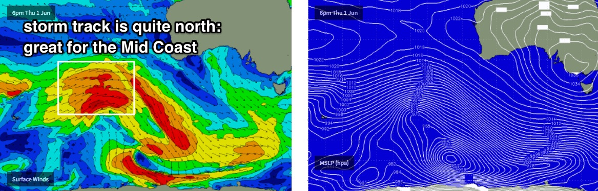
We’ve got an excellent weekend of light winds and strong, building W/SW swells, thanks to a very active storm pattern SW of WA this week. The westerly component in the swell direction will favour the Mid Coast nicely and with good winds there should be some very good waves both days.
There are three distinct pulses of swell expected between Saturday and Monday. Each is modelled to arrive in the mornings (just by coincidence), however the timing on each can never be 100% because of the enormous travel distance between the swell source and the mainland. So, allow some elasticity in the timing of each event.
The first swell is due to to reach central SA coasts early/mid morning on Saturday, so the dawn patrol may come in a little undersized. But surf size should build from 1ft across the Mid Coast to occasionally 1-2ft+ with the push of the afternoon tide. Victor won’t enjoy the westerly swell direction, but we should still see 1-2ft surf building to 2-3ft at Middleton into the afternoon.
On Sunday, the second swell - stronger than Saturday’s - is expected to arrive during the morning, so again the dawn patrol may come in under budget. But, by the afternoon we should be seeing inconsistent 2-3ft sets across the Mid Coast with 2-3ft+ waves at Middleton.
Both coasts should be very clean with light winds both days.
Next week (Jun 5 onwards)
The third, final pulse form this series of storms will then arrive overnight Sunday, probably in the early hours of the morning. The bulk swell energy will be located some distance behind, so we’re looking at the biggest surf from this event through Monday afternoon.
However, we should see up to 3ft+ across the Mid at times (mainly on the afternoon tide, smaller otherwise, especially in the morning), and a weak front pushing just south of the state will swing winds around to a light southerly, but probably not enough to affect conditions too much.
Down south, wave heights should build up to 4-5ft at Middleton on Monday - disproportionately small compared to the likely buoy data (and surf size across exposed parts of the state) but the strong westerly component in the swell direction always shaves off a significant amount of size as the swells bend around Kangaroo Island.
Model guidance has dissipated the projected cut-off low in the Bight for the following days, so we’re looking at light variable winds and strong, though easing swells through Tuesday with clean conditions across most coasts. There should still be more than enough residual swell for occasional 2ft+ waves across the Mid Coast, with bigger surf at Victor pushing 3-4ft at Middleton.
Beyond this, the broader synoptic pattern is expected to remain vigorous across the Southern Indian Ocean, which suggests an extended period of moderate, long period groundswells for some time. A smaller though still quality new W/SW groundswell is expected on Wednesday, with a solid, long period though very inconsistent follow up W/SW due later Thursday and into Friday.
Because of the northern latitude of the storm track, the swell direction will retain plenty of west which points towards a great run of waves for the Mid Coast (local winds pending, of course), all the way through into next weekend and beyond. More on this in Monday’s update.
Comments
That you Rog?
South Port looking the goods again this morning! Stacks of lines through the gulf too. Looking forward to the afternoon kick.
Already starting to show much stronger across the Mid Coast. Good 2-3ft sets on offer.
South Port looking unreal.. again!
And Knights dishing up some fun wedges. Ain't a lot of size at Victor which shows just how west the swell direction is.