Good swell from Friday afternoon but with average winds

South Australian Forecast by Craig Brokensha (issued Wednesday 22nd February)
Best Days: Mid Coast later Friday and Saturday, South Coast Monday morning and Wednesday morning
Recap
Great waves yesterday morning with clean conditions and 3ft sets off Middleton, bigger at Waits and Parsons, while the Mid Coast saw easing 1-1.5ft sets.
Today the surf was small to tiny down South but nice and clean, while the Mid Coast is seeing a building W/NW windswell.
This week and weekend (Feb 23 – 26)
Currently an intense mid-latitude low is moving in and across the state, with a fetch of strong to near gale-force W/SW winds being aimed into the Mid Coast.
On top of an increase in windswell this afternoon, some mid-period W/SW swell will be generated for tomorrow morning to 2ft, easing through the day.
The low is actually too north for the South Coast, and will weaken significantly while moving into its swell window overnight.
With this no major size is due at all, with 1ft of windswell across Middleton, not much bigger at Waits and Parsons.
A gusty but easing W/SW tending SW wind will also create poor conditions.
 Our better pulses of SW groundswell Friday and Saturday are still on track, with a broad fetch of strong to gale-force W/SW winds currently being generated south of WA and the Bight.
We'll see this generate a good pulse of SW groundswell tomorrow, building to 3ft at Middleton into the afternoon with 1-2ft sets on the Mid Coast.
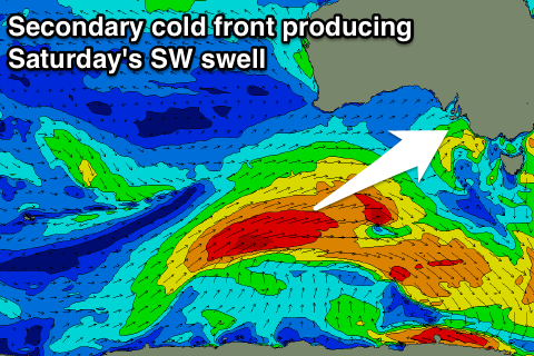
A secondary fetch of broad W/SW gales moving over the active sea state generated by the first system, will project a touch closer to us as well, generating a moderate sized SW groundswell for Saturday.
Bigger 3-4ft sets are due off Middleton as 1-2ft waves continue across the Mid Coast, easing back Sunday from 3ft and 1-1.5ft respectively. Our models are over-forecasting the swell size Saturday and Sunday (especially on the backside of the event) with it incorrectly mixing the easing groundswell with a small S/SE windswell.
Looking at the winds and Friday will be poor with a a moderate to fresh S'ly tending S/SE breeze, SE tending S/SE Saturday while Sunday morning will offer slightly better but still average E/SE breezes through the morning.
Next week onwards (Feb 17 onwards)
Monday will be much cleaner on the South Coast with a morning NE offshore but there isn't expected to be much size left, 2ft Middleton and maybe 3ft sets at Waits, tiny into the afternoon and Tuesday morning.
Favourable N'ly winds are due Tuesday and Wednesday mornings with a small kick in SW swell Tuesday afternoon/Wednesday. This swell from a small polar low isn't due to really offer more than 2ft waves at Middleton.
Longer term some new SW groundswell is due late week from a slow moving low through the Southern Ocean, but this will be with what looks to be onshore S/SW winds.