Acute W'ly swell for the end of the week, easing winds Friday

South Australian Forecast by Craig Brokensha (issued Monday 26th December)
Sign up to Swellnet’s newsletter and receive the South Australian Forecaster Notes and latest news sent directly to your inbox. Upon signup you'll also enter the draw to win a surf trip to P-Pass for you and a mate. It doesn’t get much easier so click HERE to sign up now.
Best Days: Mid Coast tomorrow afternoon keen surfers, Friday, Saturday
Recap
Much smaller 1-1.5ft waves yesterday across the Mid Coast after Monday's strong swell, with 2ft'ers across magnets on the incoming tide. The South Coast was fun with a good 3ft of swell off Middleton and good conditions most of the day.
A strong tropical low moved across us overnight bringing large rainfall totals, strong winds and a NW windswell on the Mid Coast to 2ft or so.
The South Coast was clean but near flat.
This week and weekend (Dec 29 – Dec 1)
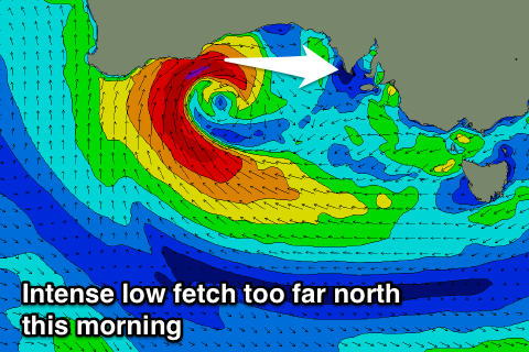 All eyes are on a secondary intense mid-latitude currently in the Bight, with a fetch of W'ly gales being produced under the WA coast.
This morning winds were too far north even for the Mid Coast on the top of the low, but this afternoon we should see the low drift slowly south-east while weakening. This will see a weakening fetch of W'ly winds aimed in the Mid Coast's swell window.
With the initial stages of the low being out of the Mid Coast's swell window, a slight downgrade in size and timing of the swell is expected.
No major size is expected early tomorrow morning when conditions are due to be clean and winds light, but into the afternoon 2ft sets should develop on the Mid along with a moderate to fresh NW'ly.
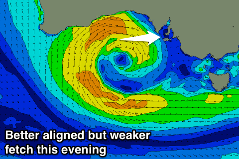 A peak is expected through Friday to a consistent 2ft+ with a moderate W/NW wind, easing into the afternoon. Therefore keep an eye on the cams and obs for fun window of waves.
With the low staying so far north, the South Coast isn't due to see any size at all with an inconsistent W/SW groundswell only coming in at 1-1.5ft across Middleton Friday, not much bigger at Waits and Parsons.
Into the weekend the W/SW swell should ease back from 1-2ft on the Mid Coast, with small waves continuing down South. An early W/NW breeze should create clean conditions down South with a more variable breeze across the Mid Coast.
A weak front moving through Sunday will create average conditions with SW winds, and this will be as a new inconsistent W/SW groundswell peaks.
The source of this swell is a strong but very distant polar low south-east of Madagascar and between Heard Island.
The low has since weakened leaving a very inconsistent W/SW groundswell to travel towards us.
Middleton is expected to offer 2ft waves, with sets possibly near 3ft, while the Mid should hang around 1ft. As touched on, conditions will be poor with an onshore wind.
Longer term there's nothing significant on the cards, so try and Surf Friday and Saturday on the Mid.
Comments
As expected the surf was tiny on the Mid this morning, but the swell has just hit the Cape du Couedic wave buoy, so expect some better swell to arrive around midday (sets to 1ft are now showing on the coast).
There it is..