Good Mid Coast waves Saturday, South Coast Sunday

South Australian Forecast by Craig Brokensha (issued Friday 2nd December)
Sign up to Swellnet’s newsletter and receive the South Australian Forecaster Notes and latest news sent directly to your inbox. Upon signup you'll also enter the draw to win a surf trip to P-Pass for you and a mate. It doesn’t get much easier so click HERE to sign up now.
Best Days: Both coasts tomorrow (best Mid), South Coast Sunday, early Sunday on the Mid, Mid Coast later Monday
Recap
Tiny waves on the Mid Coast yesterday, pulsing a little into the afternoon with the incoming tide and light sea breezes. The South Coast was also fun and around 2-3ft at magnets with a variable breeze through the morning.
Today onshore winds were blowing down South with a small swell, and the Mid was around 0.5-1ft with an early light offshore.
A good new W/SW groundswell should build to 2ft on the sets later today and with winds tending back to the S/SE.
This weekend (Dec 3 - 4)
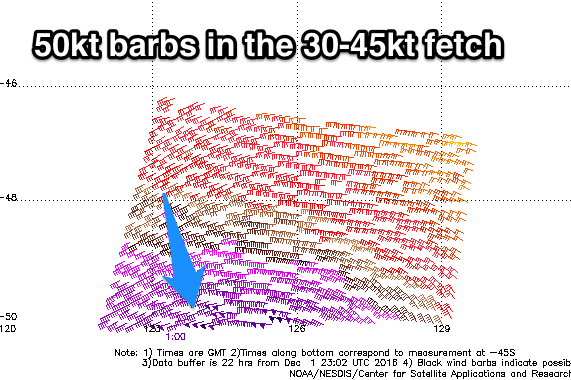 Satellite observations are in regarding the slow moving and stalling mid-latitude low responsible for the weekend's swell and while it's come in as forecast with gale to severe-gale W/SW winds being aimed through our south-western swell window, a couple of stronger storm-force (50kt) barbs have been registered.
This is positive and there's been no real change to the size of the swell forecast for the weekend.
This afternoon's increase in W/SW swell is just the start of a larger increase in SW swell due through the weekend. The Mid Coast should come in around 2ft+ tomorrow on the favourable parts of the tide easing off from 2ft on the sets Sunday morning.
Middleton should build from 3-4ft Saturday morning, to 5ft on the sets into the late afternoon, easing from 3-4ft+ Sunday morning.
Conditions will be great on the Mid tomorrow with a E/SE offshore, tending variable ahead of possible afternoon sea breezes. The South Coast will be OK but not great with a moderate E/NE wind ahead of afternoon sea breezes.
Sunday is the pick down South with a N/NE offshore wind, tending N/NW late morning and persisting all afternoon ahead of a late onshore change.
Next week onwards (Dec 5 onwards)
Monday will be average across both coasts with a fresh SW-S/SW wind in the wake of Sunday evening's change, but the Mid Coast will see a new W/SW swell to 1-2ft.
Later in the day winds are due to swing back to the S/SE, so the late session should be fun.
A more variable breeze Tuesday morning should create cleaner conditions down South but the swell will be small and fading from 1-2ft. The Mid will also be easing from 1ft+.
Longer term, we should see a strong but acute W/SW groundswell late next week/Saturday but we'll have another look at this Monday. Have a great weekend!
Comments
Sneaky peak at the Hump this morning. Typical Mid Coast (super)inconsistency but some nice little waves by the looks of things.
Pretty solid at Victor too! Gawd I don't miss paddling through all of that whitewater.