Great weekend coming up

South Australian Forecast by Craig Brokensha (issued Monday 28th November)
Best Days: Keen surfers South Coast tomorrow morning, and swell magnets Thusday morning, Mid Coast late Friday through Sunday, South Coast Saturday morning and more so Sunday morning
Recap
Small lumpy waves to start the weekend down South with Sunday offering much better conditions with more swell and offshore NE winds up until just before midday.
The Mid Coast surprisingly provided swell all weekend with 1ft sets for the most part, a little bigger at times.
Today the swell was back to a tiny 0.5ft on the Mid, with clean fun waves continuing down South off Middleton.
This week and weekend (Nov 29 – Dec 4)
The coming week isn't too special at all, with small easing surf through tomorrow, further Wednesday.
A light E'ly is expected down South tomorrow morning but with small easing 2ft sets off Middleton and 3ft waves out at Waits and Parsons, it's not really worth the drive from Adelaide.
Onshore S'ly winds will then kick in Wednesday creating poor conditions. The Mid isn't due to offer any surf either.
A small kick in new inconsistent SW swell is due later Thursday from a relatively weak but broad polar low that's currently south-west of WA.
Winds are only in the strong to gale-force range, and with this small inconsistent 2ft waves are due off Middleton with 0.5-1ft sets on the Mid. The morning will be smaller.
Conditions are looking best Thursday morning with a light offshore N/NE breeze before an onshore change moves in through the afternoon.
 This change will be linked to a strong and slow moving mid-latitude low pushing in from the west.
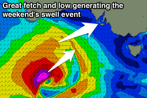
As talked about last update, a large W/SW groundswell is due off this low, with it expected to develop under WA Wednesday, deepening and projecting a slow moving fetch of gale to severe-gale W/SW winds through our western swell window right until the end of the week.
The low will track towards Tasmania, seeing the swell swing in direction from the W/SW to SW during its lifecycle, while also long-lived in nature.
The W/SW groundswell should kick later Friday and peak Saturday morning, easing slowly Sunday from a SW direction.
The Mid Coast should kick to 2ft+ later in the day as morning SW winds swing back to the S/SE into the evening. Middleton is due to reach 3-4ft by dark but with poor conditions.
Come Saturday we should see strong 2-3ft sets on the Mid with 4-5ft+ sets off Middleton. Conditions will be excellent for the Mid with an E/SE offshore, while the South Coast will be OK with a light E/NE offshore.
As the swell eases slowly Sunday clean conditions are due across both coasts with a NE'ly on the Mid, and N/NE winds down South.
We'll have a check of this forecast again on Wednesday so check back then for any slight changes.