Fun Thursday morning and then better from Sunday onwards

South Australian Forecast (issued Wednesday 26th August)
Best Days: Thursday morning, Saturday morning for keen surfers in protected spots, Sunday morning, Monday, Tuesday morning
Recap
Poor conditions yesterday down South with an easing swell, while the Mid was clean but tiny.
Today a strong new S/SW groundswell has filled in and our possible window of cleaner conditions through the morning came through with variable breezes and good lumpy sets to 3-4ft at Middleton through the morning. A further pulse in size should be seen through the day but weak onshore breezes have since developed. The Mid has picked up more size than expected to clean 1-1.5ft sets.
This week and weekend (Aug 27 - 30)
Today's strong pulse of S/SW groundswell is expected to ease back through tomorrow but steady through the day as a reinforcing SW groundswell fills in.
This should keep 3-4ft sets hitting Middleton with 5-6ft waves at Waits and Parsons, and winds are also looking better with a morning variable breeze due before increasing from the S/SE into the afternoon.
Friday will then remain average with easing levels of swell and moderate to fresh SE tending S/SE winds. The Mid should hold tiny and clean waves for beginners for the rest of the week.
The weekend is looking OK and best Sunday. Saturday will see small levels of leftover swell to 2-3ft at Middleton and the 4ft range at Waits and Parsons but with a moderate to fresh E'ly tending SE wind. This will only favour a few select locations.
Sunday should see similar sized surf through the morning with a better NE wind resulting in improving conditions, and the first of two inconsistent but strong SW groundswell pulses is due through the day. This should build to a stronger 3ft at Middleton and 4-5ft at Waits but winds will swing back more E/SE after lunch.
 Next week onwards (Aug 31 onwards)
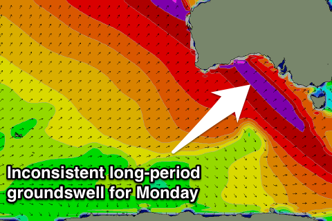
A secondary stronger pulse of long-range SW groundswell is due Monday morning, produced by a broad and elongated fetch of severe-gale to storm-force winds in the southern Indian Ocean, in our far swell window.
This swell should offer infrequent 3ft+ sets across Middleton Monday morning and 4-5ft+ waves at Waits and Parsons early (smaller later) under fresh and gusty N/NE winds.
Tuesday looks to be smaller with as winds swing more N/NW to W/NW.
A small and weak front moving in through the Bight early next week should produce some new W/SW swell for Wednesday across the Mid, small down South but with onshore winds.
Behind this we may see some better swell into the following weekend, but check back here on Friday for an update on this.