Good Saturday morning, fun Monday and Wednesday

 South Australian Forecast (issued Friday 13th March)
Best Days: Saturday morning down South, Monday down South, Wednesday down South, later in the week
Recap
Swell dropped back to a less consistent 1-1.5ft yesterday with the odd 2ft bomb on the Mid while today a reinforcing swell is continuing to provide good 1-2ft sets across the Mid with morning offshores.
The South Coast was less than ideal with onshore winds yesterday but plenty of swell, while today was better and improving with a cross-offshore and light E/NE breeze.
This weekend and next week (Mar 14 - 20)
Today's swell is expected to drop back through the coming weekend with great winds for both coasts tomorrow and poor winds for the South Coast Sunday.
Size wise the Middleton stretch should still offer good 3-4ft sets early tomorrow with 5ft sets at Waits and Parsons under N/NW breezes. A shift to less favourable W/NW breezes is due around midday ahead of an onshore change early afternoon.
The Mid will be clean again early but smaller and around an inconsistent 1-1.5ft.
Sunday looks poor with a moderate SE'ly down South and clean but tiny 0.5-1ft peelers on the Mid.
Monday's S/SW groundswell that was wiped off the forecast Wednesday is on the cards again, but its direction will nearly be dead south. This will be generated by a strengthening polar front firing up towards Victoria, right on the edge of our southern swell window.
No major size is due but there should be inconsistent 2ft sets across Middleton with 2-3ft sets at Waits and Parsons.
Winds will be better than Sunday as well with a N/NE offshore creating clean conditions before weak sea breezes kick in mid-late afternoon.
Tuesday will be small to tiny and not really worth the drive from Adelaide with W/NW winds all day favouring only a select couple of locations.
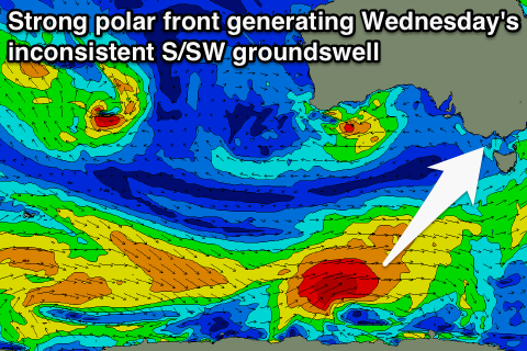
A new S/SW swell for Wednesday is still on track with a more consolidated polar front due to fire up along the polar shelf during the weekend. A fetch of gale to severe-gale W/SW winds will be generated through our southern swell window, producing an inconsistent and fun S/SW groundswell to 2-3ft at Middleton and 3-4ft at Waits. This swell might be seen on dark Tuesday.
Winds should persist from the NW to W/NW favouring Middleton and Waits Point.
A small and funky W/SW swell is due in the mix Wednesday from a weak mid-latitude low forming in the Bight Sunday and Monday.
A weak fetch of W'ly winds will be projected in the Mid's swell window, kicking up 1-2ft waves Wednesday.
Into the end of the week we're looking at another good 2ft pulse of W/SW swell Thursday from a similar system pushing through the Bight, but a much stronger mid-latitude low is forecast to develop south of WA and push up and into us Thursday afternoon, generating a large mix of W/SW and SW swell for Friday. More on this Monday though. Have a great weekend!