Fun week of waves across both coasts

South Australian Forecast (issued Monday 15th December)
Best Days: Every morning down South besides Friday, Mid Coast Wednesday morning and Friday morning
Recap
Saturday was great down across the South Coast with a new SW groundswell filling in under freshening offshore winds from the N/NE that then swing more NW around midday and then stronger W'ly ahead of a late onshore change. Middleton offered 3ft to occasionally 4ft waves while Waits and Parsons were in the 4-5ft range and best through the morning. The late onshore change eased off into Sunday morning with a lighter lingering onshore wind from the S'th seen at dawn Sunday before increasing shortly thereafter.
The Mid was in the tiny 1ft range for most of the weekend, and today continued to 1ft, with the odd bigger bomb to 1.5ft seen across swell magnets. The South Coast was smaller and lumpier with a light E'ly wind at dawn before quickly freshening and swinging SE.
 This week (Dec 16 - 19)
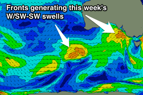
Our good pulse of W/SW groundswell is still on for tomorrow and Wednesday but there'll also be some sizey SW groundswell in the mix of the South Coast as well.
This is being generated by a strong front approaching from the west, aiming a fetch of strong to gale-force SW winds through our swell window. The change will push through during the mid-late morning with early W/NW winds swinging strong SW, so go early down South if you're looking for a wave.
Size wise we should see the Mid Coast pulsing to 2ft to nearly 3ft during the afternoon with a bit of windswell in the mix, while the South Coast should see 3-4ft waves at Middleton and 4-5ft sets at Waits.
Wednesday morning looks the best for the Mid as the swell eases from 2ft and winds tend variable and likely light SE while the South Coast should also be nice with a light W/NW'ly favouring Middleton. There won't be a drop in size down South though as a trailing fetch of SW winds on the tail of the front pushing through the Bight generates a reinforcing SW groundswell a similar size to Tuesday's.
This should also keep 1-2ft sets hitting the Mid but winds will again be only good for a short period down South with an early W/NW'ly giving way to a gusty W/SW change mid-late morning.
The change will be relate to another weaker frontal systems pushing up and through the Bight before clipping us and with this we should see a renewal of W/SW swell energy Friday to 1-2ft on the Mid and 3-4ft at Middleton with 4-5ft+ sets at Waits.
Unfortunately winds look to still be onshore from the S/SW tending S/SE on Friday down South but the Mid is expected to be clean with a morning S/SE breeze.
This weekend onwards (December 20 onwards)
Friday's swell will continue to ease through Saturday and further into Sunday morning as winds slowly improve for the South Coast. A light E/NE'ly is due Saturday morning and then NE winds Sunday morning, but we'll review this again Wednesday.
Into next week there's nothing too major on the cards and winds will again become terrible and persist from the S/SE for the most part. This will be due to a large blocking high setting up camp in the Bight, so make the most of the coming period of surf.