Fading surf, large late next week

Bali and Mentawais forecast by Craig Brokensha (issued Thursday 20th September)
Best Days: Swell magnets tomorrow and Saturday morning, similar Tuesday morning and then Thursday onwards
This week through next weekend (Sep 21 - 30)
Bali: A good new S/SW groundswell on the coast later yesterday and today, with it now on the ease.
We'll see the surf continuing to drop through tomorrow from the 6ft range at exposed south swell magnets early morning, smaller into the weekend and bottoming out Sunday/Monday.
The new mid-period S/SW swell for Tuesday is still on the cards with it starting to be generated by a polar front south-west of WA.
 A broad fetch of strong SW winds are projecting slowly towards WA but will then pass under Australia, with a minimal increase in size due Tuesday to 4ft across south swell magnets.
We look ahead to our better groundswells due into the end of next week and weekend.
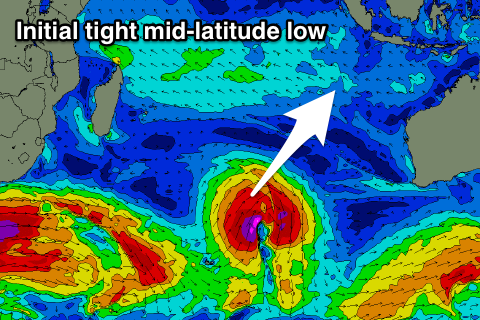
The first long-period SW groundswell is still on the cards, with a small and intense mid-latitude low forming in the central Indian Ocean tomorrow afternoon, projecting a fetch of severe-gale to likely storm-force SW winds towards Indonesia.
The swell is due to arrive Wednesday and build through the afternoon ahead of a peak Thursday morning in the 4-6ft.
We should see the swell ease through the day ahead of a less consistent and long-range SW groundswell building Friday afternoon and further through Saturday ahead of a peak into the evening, easing very slowly Sunday.
This swell will be generated by a very strong and prolonged storm that's formed south-east of South Africa today and will project a slow moving fetch of severe-gale to storm-force W/SW winds through our distant swell window.
The progression will move further east and away from South Africa through the weekend while continuing to generate severe-gales, breaking down around the Heard Island region on Monday.
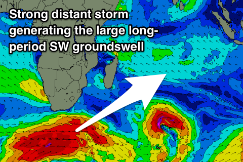 We should see a large, long-period though inconsistent SW groundswell from this storm, with the long-period forerunners arriving Friday with a late increase in size likely to 4-6ft across magnets, with the bulk of the swell filling in Saturday and reaching 6-8ft through the day.
The easing trend will likely be slow with dropping surf from a similar range Sunday. We'll review this Tuesday though.
Winds over the coming period will be generally weak with E/SE-SE trades, variable each morning and a little fresher through the weekend.
16 day Bali Forecast Graph
16 day East Java Forecast Graph
16 day Sumbawa Forecast Graph
Ments: We should of seen some better sized S'ly groundswell across the region yesterday and today, with it due to ease off through tomorrow along with some mid-period S/SE trade-swell.
The surf will really bottom out through Sunday to Tuesday ahead of the new groundswell from the mid-latitude low which looks to arrive later in the day ahead of a peak Wednesday.
The swell will be a little more S/SW for us and come in at 4-6ft, easing into Thursday ahead of the large long-period SW groundswell.
This groundswell will come in with more size across the Ments and with a touch more consistency, with it kicking large Friday and to 8ft on the sets by dark, with the odd bigger cleanup possible on Saturday morning before it slowly eases.
Winds look as per usual, persistent from the SE-S/SE and fresh through the days, lighter and more E/SE each morning.
16 day Mentawai forecast graph
16 day Nias forecast graph
16 day South Sumatra forecast graph