Relatively average period, better from later next week

Bali and Mentawais forecast by Craig Brokensha (issued Tuesday 18th September)
Best Days: Wednesday, Thursday, and Friday, Wednesday onwards next week
This week and next (Sep 19 - 28)
Bali: Good large pulses of swell later Friday and into the weekend, but a more S'ly and reinforcing pulse due yesterday came in a touch under expectations, though it was very south in nature and created late in the regions south swell window.
This swell should be easing into today and will drop further tomorrow morning ahead of our new long-period S/SW groundswell which will be the last significant event for at least a week and a half.
This large long-period S/SW groundswell was generated by a very strong polar low that developed in the Heard Island region late last week, generating a slow moving fetch of severe-gale to storm-force W/SW winds through our southern swell window.
 The swell pushed into WA yesterday afternoon, easing this morning with it due to arrive through tomorrow with a peak due either overnight or early Thursday morning.
Exposed south facing breaks should kick to at least 6-8ft by close of play tomorrow, with easing sets from the 8ft range on Thursday morning, smaller Friday and down from 6ft max. With the southerly direction, most of the Bukit reefs will be smaller.
Weak E/SE trades are due through this period, variable for a good period each morning and remaining so through next week.
The swell will really tail away through the weekend and become small with no significant swells on the cards until next weekend.
Before this, a small mid-period S/SW swell should be seen Tuesday, generated by a relatively weak polar frontal system firing up towards WA over the coming days.
We're only looking at maybe 4ft sets across swell magnets Tuesday, easing into Wednesday.
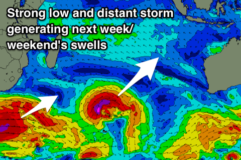
A slightly better and stronger SW groundswell is due Thursday, generated by an intense but short-lived low firing up south-east of Madagascar. Better sets to 4-5ft are due off this swell on Thursday, while a very distant but strong storm developing under South Africa looks to generate a very inconsistent long-period groundswell for next weekend. More on this Thursday.
16 day Bali Forecast Graph
16 day East Java Forecast Graph
16 day Sumbawa Forecast Graph
Ments: The outlook for the region isn't too flash at all, with the swell energy for Bali being generated late in our southern swell window, if at all within it.
Some new long-period S'ly groundswell energy should be seen to fill in tomorrow, providing infrequent 5-6ft waves across south swell magnets, with a secondary pulse maintaining 5ft sets Thursday before easing off into the end of the week and weekend.
Our pesky SE-S/SE winds are due to persist through the period, with a S'ly trade-swell also in the mix through the coming week from strong persistent SE winds between us and Western Australia.
There's then nothing of significance until that good SW groundswell fills in the middle of next week, providing hopefully 4-6ft sets.
The larger long-period and distant groundswell is looking better for Friday and into the weekend of the 29/30th, but more on this Thursday.
16 day Mentawai forecast graph
16 day Nias forecast graph
16 day South Sumatra forecast graph